Santa Ana - Santee
Flight / Schedule
Santa Ana - Santee
Aircraft
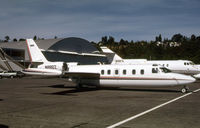
Learjet 35Registration
N880Z
MSN
35A-591
Year of Manufacture
1985
Operator
Aeromedevac Air AmbulanceDate
December 27, 2021 at 07:14 PM
Type
CRASHFlight Type
Ferry
Flight Phase
Landing (descent or approach)
Crash Site
City
Crash Location
Santee-Gillespie Field California
Region
North America • United States of America
Narrative Report
On December 27, 2021 at 07:14 PM, Santa Ana - Santee experienced a crash involving Learjet 35, operated by Aeromedevac Air Ambulance, with the event recorded near Santee-Gillespie Field California.
The flight was categorized as ferry and the reported phase was landing (descent or approach) at a city crash site.
4 people were known to be on board, 4 fatalities were recorded, 0 survivors were identified or estimated. This corresponds to an estimated fatality rate of 100.0%.
Crew on board: 2, crew fatalities: 2, passengers on board: 2, passenger fatalities: 2, other fatalities: 0.
On December 27, 2021, about 1914 Pacific standard time, a Gates Learjet Corporation 35A, N880Z, was destroyed when it was involved in an accident near El Cajon, California. The 2 pilots, and 2 flight nurses were fatally injured. The airplane was operated as a Title 14 Code of Federal Regulations Part 91 repositioning flight. Earlier in the day, the flight crew had flown from Lake Havasu City Airport (HII), Lake Havasu, Arizona, to John Wayne / Orange County Airport (SNA), Santa Ana, California, for a patient transfer. They departed SNA about 1856 to reposition to their home base at Gillespie Field (SEE), El Cajon, California. Review of preliminary communication recordings revealed that at 1908:23, the pilot contacted the SEE Air Traffic Control Tower (ATCT) and reported to the controller they were on the GPS approach to runway 17. The controller issued the current wind and cleared the pilot to land on runway 17. At 1912:03, the pilot reported the airport in sight and requested to squawk VFR. The controller did not acknowledge the request to squawk VFR, however, he reissued the landing clearance for runway 17. At 1912:13, the pilot requested to land on runway 27. The controller asked the pilot if they wanted to cancel their IFR flight plan, to which the pilot replied, “yes sir.” The controller acknowledged that the IFR cancelation was received and instructed the pilot to overfly the field and enter left traffic for runway 27R and cleared them to land runway 27R. At 1912:30, the pilot requested that the runway lights for runway 27R be increased, however, the controller informed them that the lights were already at 100 percent. Preliminary Automatic Dependent Surveillance-Broadcast (ADS-B) data showed that after departure from SNA, the flight made a left turn out over the waters of the Pacific Ocean and flew generally south – southeast along the coast and ascended to a cruise barometric altitude of about 11,000 ft sea level (MSL). After the flight passed Carlsbad, California, the airplane turned left and began to descend toward SEE. As shown in figure 1, ADS-B data showed that the airplane overflew SEE at a barometric altitude of about 775 ft MSL (407 ft above ground level) and entered a left downwind for runway 27R. While on the downwind leg, the airplane descended to a barometric altitude of 700 ft MSL, then ascended to a barometric altitude of 950 ft MSL while on the base leg. The last recorded ADS-B target was at 1914:09, at a barometric altitude of 875 ft MSL. Examination of the accident site revealed that the airplane struck a set of power lines and subsequently impacted the yard of a residential home about 1.43 nautical miles east of the approach end of runway 27R. The airplane came to rest upright on a heading of about 118°, at an elevation of about 595 ft msl. The wreckage debris path was oriented on a heading of about 310° and was about 186 ft long and 90 ft wide. All major structural components of the airplane were located throughout the wreckage debris path. The wreckage was recovered to a secure location for further examination. At 1855, recorded weather data at SEE showed weather conditions were variable wind at 5 knots, visibility of 3 statute miles, mist, broken cloud layer at 2,000 ft, overcast cloud layer at 2,600 ft, temperature of 10° C, dew point temperature of 8° C, and an altimeter setting of 29.98 inches of mercury. No precipitation was indicated. At 1955, SEE reported a variable wind of 5 knots, visibility 3 statute miles, mist, broken cloud layer at 1,100 ft, overcast cloud layer at 2,600 ft, temperature of 10°C, dew point temperature of 8°C, and an altimeter setting of 29.96 inches of mercury. No precipitation was indicated.
Aircraft reference details include registration N880Z, MSN 35A-591, year of manufacture 1985.
Fatalities
Total
4
Crew
2
Passengers
2
Other
0
Crash Summary
On December 27, 2021, about 1914 Pacific standard time, a Gates Learjet Corporation 35A, N880Z, was destroyed when it was involved in an accident near El Cajon, California. The 2 pilots, and 2 flight nurses were fatally injured. The airplane was operated as a Title 14 Code of Federal Regulations Part 91 repositioning flight. Earlier in the day, the flight crew had flown from Lake Havasu City Airport (HII), Lake Havasu, Arizona, to John Wayne / Orange County Airport (SNA), Santa Ana, California, for a patient transfer. They departed SNA about 1856 to reposition to their home base at Gillespie Field (SEE), El Cajon, California. Review of preliminary communication recordings revealed that at 1908:23, the pilot contacted the SEE Air Traffic Control Tower (ATCT) and reported to the controller they were on the GPS approach to runway 17. The controller issued the current wind and cleared the pilot to land on runway 17. At 1912:03, the pilot reported the airport in sight and requested to squawk VFR. The controller did not acknowledge the request to squawk VFR, however, he reissued the landing clearance for runway 17. At 1912:13, the pilot requested to land on runway 27. The controller asked the pilot if they wanted to cancel their IFR flight plan, to which the pilot replied, “yes sir.” The controller acknowledged that the IFR cancelation was received and instructed the pilot to overfly the field and enter left traffic for runway 27R and cleared them to land runway 27R. At 1912:30, the pilot requested that the runway lights for runway 27R be increased, however, the controller informed them that the lights were already at 100 percent. Preliminary Automatic Dependent Surveillance-Broadcast (ADS-B) data showed that after departure from SNA, the flight made a left turn out over the waters of the Pacific Ocean and flew generally south – southeast along the coast and ascended to a cruise barometric altitude of about 11,000 ft sea level (MSL). After the flight passed Carlsbad, California, the airplane turned left and began to descend toward SEE. As shown in figure 1, ADS-B data showed that the airplane overflew SEE at a barometric altitude of about 775 ft MSL (407 ft above ground level) and entered a left downwind for runway 27R. While on the downwind leg, the airplane descended to a barometric altitude of 700 ft MSL, then ascended to a barometric altitude of 950 ft MSL while on the base leg. The last recorded ADS-B target was at 1914:09, at a barometric altitude of 875 ft MSL. Examination of the accident site revealed that the airplane struck a set of power lines and subsequently impacted the yard of a residential home about 1.43 nautical miles east of the approach end of runway 27R. The airplane came to rest upright on a heading of about 118°, at an elevation of about 595 ft msl. The wreckage debris path was oriented on a heading of about 310° and was about 186 ft long and 90 ft wide. All major structural components of the airplane were located throughout the wreckage debris path. The wreckage was recovered to a secure location for further examination. At 1855, recorded weather data at SEE showed weather conditions were variable wind at 5 knots, visibility of 3 statute miles, mist, broken cloud layer at 2,000 ft, overcast cloud layer at 2,600 ft, temperature of 10° C, dew point temperature of 8° C, and an altimeter setting of 29.98 inches of mercury. No precipitation was indicated. At 1955, SEE reported a variable wind of 5 knots, visibility 3 statute miles, mist, broken cloud layer at 1,100 ft, overcast cloud layer at 2,600 ft, temperature of 10°C, dew point temperature of 8°C, and an altimeter setting of 29.96 inches of mercury. No precipitation was indicated.
Occupants & Outcome
Crew On Board
2
Passengers On Board
2
Estimated Survivors
0
Fatality Rate
100.0%
Known people on board: 4
Operational Details
Schedule / Flight
Santa Ana - Santee
Operator
Aeromedevac Air AmbulanceFlight Type
Ferry
Flight Phase
Landing (descent or approach)
Crash Site
City
Region / Country
North America • United States of America
Aircraft Details
Similar Plane Crashes
United States Signal Corps - USSC
De Havilland DH.4
The single engine airplane departed Dayton-McCook Field for a local test flight. Shortly after takeoff, the aircraft stalled and crashed, killing both occupants. Crew: Maj Oscar Brindley, Lt Col Henry Damm.
United States Signal Corps - USSC
De Havilland DH.4
Lt. Frank Stuart Patterson, son and nephew of the co-founders of National Cash Register, is killed in the crash of his DH.4M, AS-32098, at Wilbur Wright Field during a flight test of a new mechanism for synchronizing machine gun and propeller, when a tie rod breaks during a dive from 15,000 feet (4,600 m), causing the wings to separate from the aircraft. Wishing to recognize the contributions of the Patterson family (owners of NCR) the area of Wright Field east of Huffman Dam (including Wilbur Wright Field, Fairfield Air Depot, and the Huffman Prairie) is renamed Patterson Field on 6 July 1931, in honor of Lt. Patterson.
United States Signal Corps - USSC
De Havilland DH.4
The aircraft crashed in unknown circumstances.
United States Signal Corps - USSC
De Havilland DH.4
The crew was completing a training mission. At an altitude of about 4,000 feet, the aircraft entered a spin and crashed in an open field near Everman-Barron Field Airport. A crew was killed and the second occupants was injured. The aircraft was destroyed.
U.S. Air Mail Service
De Havilland DH.4
Crashed following an engine failure. Pilot fate unknown.
United States Signal Corps - USSC
De Havilland DH.4
The accident occurred in unknown circumstances.