Pontiac - Boyne City
Flight / Schedule
Pontiac - Boyne City
Aircraft
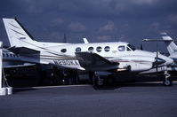
Beechcraft 90 King AirRegistration
N290KA
MSN
LW-59
Year of Manufacture
1973
Operator
N290KA LLCDate
November 15, 2021 at 12:45 PM
Type
CRASHFlight Type
Private
Flight Phase
Landing (descent or approach)
Crash Site
Airport (less than 10 km from airport)
Crash Location
Boyne City Michigan
Region
North America • United States of America
Coordinates
45.2167°, -85.0139°
Narrative Report
On November 15, 2021 at 12:45 PM, Pontiac - Boyne City experienced a crash involving Beechcraft 90 King Air, operated by N290KA LLC, with the event recorded near Boyne City Michigan.
The flight was categorized as private and the reported phase was landing (descent or approach) at a airport (less than 10 km from airport) crash site.
2 people were known to be on board, 2 fatalities were recorded, 0 survivors were identified or estimated. This corresponds to an estimated fatality rate of 100.0%.
Crew on board: 1, crew fatalities: 1, passengers on board: 1, passenger fatalities: 1, other fatalities: 0.
On November 15, 2021, about 1245 eastern standard time, a Beech E-90, N290KA, was destroyed when it was involved in an accident near Boyne City, Michigan. The airline transport pilot and passenger sustained fatal injuries. The airplane was operated as a Title 14 Code of Federal Regulations Part 91 business flight. A review of preliminary air traffic control (ATC) information revealed that the airplane departed Oakland County International Airport (PTK), Pontiac, Michigan, at 1150 on an instrument flight rules (IFR) flight plan and climbed to 16,000 ft mean sea level (msl). The airplane was enroute to Boyne City Municipal Airport (N98), Boyne City, Michigan. The airplane descended toward N98 and the pilot was cleared for the RNAV GPS Runway 27 approach. While on the final approach course, the airplane’s groundspeed gradually slowed from 129 to 88 knots over a period of one minute and the last recorded location showed the airplane was 3.3 nautical miles east of the Runway 27 threshold, about 1,500 ft msl (800 ft above ground level), and slightly left of the approach course. The airplane subsequently impacted the ground about 600 ft west of the last recorded location. Broken tree limbs indicated the airplane was in a steep descent of about 70° while on a west heading. Two witnesses located about ¼ mile southeast of the accident site heard the airplane fly overhead, followed by a loud thud. The witnesses observed very heavy sleet with low visibility conditions for about 10 minutes, before and after the accident time. The sleet had a high liquid content and would melt quickly after ground impact. An Airman’s Meteorological Information (AIRMET) for icing was valid for the accident location. Initial examination revealed the entire airplane was present at the accident site and no anomalies were noted with the airplane’s flight controls that would have precluded normal operation. The airplane was retained for further examination.
Aircraft reference details include registration N290KA, MSN LW-59, year of manufacture 1973.
Geospatial coordinates for this crash are approximately 45.2167°, -85.0139°.
Fatalities
Total
2
Crew
1
Passengers
1
Other
0
Crash Summary
On November 15, 2021, about 1245 eastern standard time, a Beech E-90, N290KA, was destroyed when it was involved in an accident near Boyne City, Michigan. The airline transport pilot and passenger sustained fatal injuries. The airplane was operated as a Title 14 Code of Federal Regulations Part 91 business flight. A review of preliminary air traffic control (ATC) information revealed that the airplane departed Oakland County International Airport (PTK), Pontiac, Michigan, at 1150 on an instrument flight rules (IFR) flight plan and climbed to 16,000 ft mean sea level (msl). The airplane was enroute to Boyne City Municipal Airport (N98), Boyne City, Michigan. The airplane descended toward N98 and the pilot was cleared for the RNAV GPS Runway 27 approach. While on the final approach course, the airplane’s groundspeed gradually slowed from 129 to 88 knots over a period of one minute and the last recorded location showed the airplane was 3.3 nautical miles east of the Runway 27 threshold, about 1,500 ft msl (800 ft above ground level), and slightly left of the approach course. The airplane subsequently impacted the ground about 600 ft west of the last recorded location. Broken tree limbs indicated the airplane was in a steep descent of about 70° while on a west heading. Two witnesses located about ¼ mile southeast of the accident site heard the airplane fly overhead, followed by a loud thud. The witnesses observed very heavy sleet with low visibility conditions for about 10 minutes, before and after the accident time. The sleet had a high liquid content and would melt quickly after ground impact. An Airman’s Meteorological Information (AIRMET) for icing was valid for the accident location. Initial examination revealed the entire airplane was present at the accident site and no anomalies were noted with the airplane’s flight controls that would have precluded normal operation. The airplane was retained for further examination.
Occupants & Outcome
Crew On Board
1
Passengers On Board
1
Estimated Survivors
0
Fatality Rate
100.0%
Known people on board: 2
Operational Details
Schedule / Flight
Pontiac - Boyne City
Operator
N290KA LLCFlight Type
Private
Flight Phase
Landing (descent or approach)
Crash Site
Airport (less than 10 km from airport)
Region / Country
North America • United States of America
Aircraft Details
Similar Plane Crashes
United States Signal Corps - USSC
De Havilland DH.4
The single engine airplane departed Dayton-McCook Field for a local test flight. Shortly after takeoff, the aircraft stalled and crashed, killing both occupants. Crew: Maj Oscar Brindley, Lt Col Henry Damm.
United States Signal Corps - USSC
De Havilland DH.4
Lt. Frank Stuart Patterson, son and nephew of the co-founders of National Cash Register, is killed in the crash of his DH.4M, AS-32098, at Wilbur Wright Field during a flight test of a new mechanism for synchronizing machine gun and propeller, when a tie rod breaks during a dive from 15,000 feet (4,600 m), causing the wings to separate from the aircraft. Wishing to recognize the contributions of the Patterson family (owners of NCR) the area of Wright Field east of Huffman Dam (including Wilbur Wright Field, Fairfield Air Depot, and the Huffman Prairie) is renamed Patterson Field on 6 July 1931, in honor of Lt. Patterson.
United States Signal Corps - USSC
De Havilland DH.4
The aircraft crashed in unknown circumstances.
United States Signal Corps - USSC
De Havilland DH.4
The crew was completing a training mission. At an altitude of about 4,000 feet, the aircraft entered a spin and crashed in an open field near Everman-Barron Field Airport. A crew was killed and the second occupants was injured. The aircraft was destroyed.
U.S. Air Mail Service
De Havilland DH.4
Crashed following an engine failure. Pilot fate unknown.
United States Signal Corps - USSC
De Havilland DH.4
The accident occurred in unknown circumstances.