Port Clinton – Cincinnati
Flight / Schedule
Port Clinton – Cincinnati
Aircraft
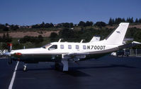
Socata TBM-700Registration
N700DT
MSN
134
Year of Manufacture
1998
Operator
Kevin C. ScottDate
August 20, 2021 at 02:40 PM
Type
CRASHFlight Type
Private
Flight Phase
Flight
Crash Site
Plain, Valley
Crash Location
Urbana Ohio
Region
North America • United States of America
Coordinates
40.1084°, -83.7524°
Narrative Report
On August 20, 2021 at 02:40 PM, Port Clinton – Cincinnati experienced a crash involving Socata TBM-700, operated by Kevin C. Scott, with the event recorded near Urbana Ohio.
The flight was categorized as private and the reported phase was flight at a plain, valley crash site.
1 people were known to be on board, 1 fatalities were recorded, 0 survivors were identified or estimated. This corresponds to an estimated fatality rate of 100.0%.
Crew on board: 1, crew fatalities: 1, passengers on board: 0, passenger fatalities: 0, other fatalities: 0.
On August 20, 2021, about 1440 eastern daylight time, a Socata TBM 700A airplane, N700DT, was destroyed when it was involved in an accident near Urbana, Ohio. The pilot sustained fatal injuries. The airplane was operated as a Title 14 Code of Federal Regulations Part 91 personal flight. Preliminary air traffic control information revealed the airplane was en route from the Erie Ottawa Airport (PCW), Port Clinton, Ohio, to the Cincinnati Municipal Airport (LUK), Cincinnati, Ohio. The airplane departed runway 9 at PCW and climbed to flight level 200 before beginning to descend. The airplane was southbound, descending to 12,000 ft mean sea level (msl), and established communications with the assigned terminal radar approach control controller. The controller cleared the pilot to descent to 10,000 ft msl and proceed direct to LUK. While descending through 12,100 ft msl, the airplane entered a left turn. The controller observed the left turn and asked the pilot if everything was alright; there was no response from the pilot. Radar contact was subsequently lost with the airplane. The controller’s further attempts to establish communications were unsuccessful. A witness, located about 2 miles south of the accident location, stated that he observed the airplane at a high altitude in a nose-dive descent toward the terrain. He reported the airplane was not turning or spinning; it was headed straight down. The witness observed no signs of distress, such as smoke, fire, or parts coming off the airplane, and he stated the airplane’s engine was at full throttle. The witness lost sight of the airplane as it descended behind some trees. The accident site was located 1.3 miles northwest of the last radar contact. The accident site showed the airplane impacted trees, two powerlines, and the terrain in a left-wing low attitude. The initial ground scar, located in a residential yard, contained separated components of the left wing. The airplane crossed a highway, struck trees and a ditch, and then continued into mature potato and soybean fields. The airplane wreckage was scattered at a distance of about 2,050 ft along a measured magnetic heading of 275°. According to acquaintances of the pilot, the pilot purchased the airplane about 9 days before the accident. Following the purchase, the pilot and a flight instructor completed several hours of ground school and 15.5 hours of dual instruction in the airplane.
Aircraft reference details include registration N700DT, MSN 134, year of manufacture 1998.
Geospatial coordinates for this crash are approximately 40.1084°, -83.7524°.
Fatalities
Total
1
Crew
1
Passengers
0
Other
0
Crash Summary
On August 20, 2021, about 1440 eastern daylight time, a Socata TBM 700A airplane, N700DT, was destroyed when it was involved in an accident near Urbana, Ohio. The pilot sustained fatal injuries. The airplane was operated as a Title 14 Code of Federal Regulations Part 91 personal flight. Preliminary air traffic control information revealed the airplane was en route from the Erie Ottawa Airport (PCW), Port Clinton, Ohio, to the Cincinnati Municipal Airport (LUK), Cincinnati, Ohio. The airplane departed runway 9 at PCW and climbed to flight level 200 before beginning to descend. The airplane was southbound, descending to 12,000 ft mean sea level (msl), and established communications with the assigned terminal radar approach control controller. The controller cleared the pilot to descent to 10,000 ft msl and proceed direct to LUK. While descending through 12,100 ft msl, the airplane entered a left turn. The controller observed the left turn and asked the pilot if everything was alright; there was no response from the pilot. Radar contact was subsequently lost with the airplane. The controller’s further attempts to establish communications were unsuccessful. A witness, located about 2 miles south of the accident location, stated that he observed the airplane at a high altitude in a nose-dive descent toward the terrain. He reported the airplane was not turning or spinning; it was headed straight down. The witness observed no signs of distress, such as smoke, fire, or parts coming off the airplane, and he stated the airplane’s engine was at full throttle. The witness lost sight of the airplane as it descended behind some trees. The accident site was located 1.3 miles northwest of the last radar contact. The accident site showed the airplane impacted trees, two powerlines, and the terrain in a left-wing low attitude. The initial ground scar, located in a residential yard, contained separated components of the left wing. The airplane crossed a highway, struck trees and a ditch, and then continued into mature potato and soybean fields. The airplane wreckage was scattered at a distance of about 2,050 ft along a measured magnetic heading of 275°. According to acquaintances of the pilot, the pilot purchased the airplane about 9 days before the accident. Following the purchase, the pilot and a flight instructor completed several hours of ground school and 15.5 hours of dual instruction in the airplane.
Occupants & Outcome
Crew On Board
1
Passengers On Board
0
Estimated Survivors
0
Fatality Rate
100.0%
Known people on board: 1
Operational Details
Schedule / Flight
Port Clinton – Cincinnati
Operator
Kevin C. ScottFlight Type
Private
Flight Phase
Flight
Crash Site
Plain, Valley
Region / Country
North America • United States of America
Aircraft Details
Similar Plane Crashes
United States Signal Corps - USSC
De Havilland DH.4
The single engine airplane departed Dayton-McCook Field for a local test flight. Shortly after takeoff, the aircraft stalled and crashed, killing both occupants. Crew: Maj Oscar Brindley, Lt Col Henry Damm.
United States Signal Corps - USSC
De Havilland DH.4
Lt. Frank Stuart Patterson, son and nephew of the co-founders of National Cash Register, is killed in the crash of his DH.4M, AS-32098, at Wilbur Wright Field during a flight test of a new mechanism for synchronizing machine gun and propeller, when a tie rod breaks during a dive from 15,000 feet (4,600 m), causing the wings to separate from the aircraft. Wishing to recognize the contributions of the Patterson family (owners of NCR) the area of Wright Field east of Huffman Dam (including Wilbur Wright Field, Fairfield Air Depot, and the Huffman Prairie) is renamed Patterson Field on 6 July 1931, in honor of Lt. Patterson.
United States Signal Corps - USSC
De Havilland DH.4
The aircraft crashed in unknown circumstances.
United States Signal Corps - USSC
De Havilland DH.4
The crew was completing a training mission. At an altitude of about 4,000 feet, the aircraft entered a spin and crashed in an open field near Everman-Barron Field Airport. A crew was killed and the second occupants was injured. The aircraft was destroyed.
U.S. Air Mail Service
De Havilland DH.4
Crashed following an engine failure. Pilot fate unknown.
United States Signal Corps - USSC
De Havilland DH.4
The accident occurred in unknown circumstances.