Faribault - Missoula
Flight / Schedule
Faribault - Missoula
Aircraft
Cessna 425 ConquestRegistration
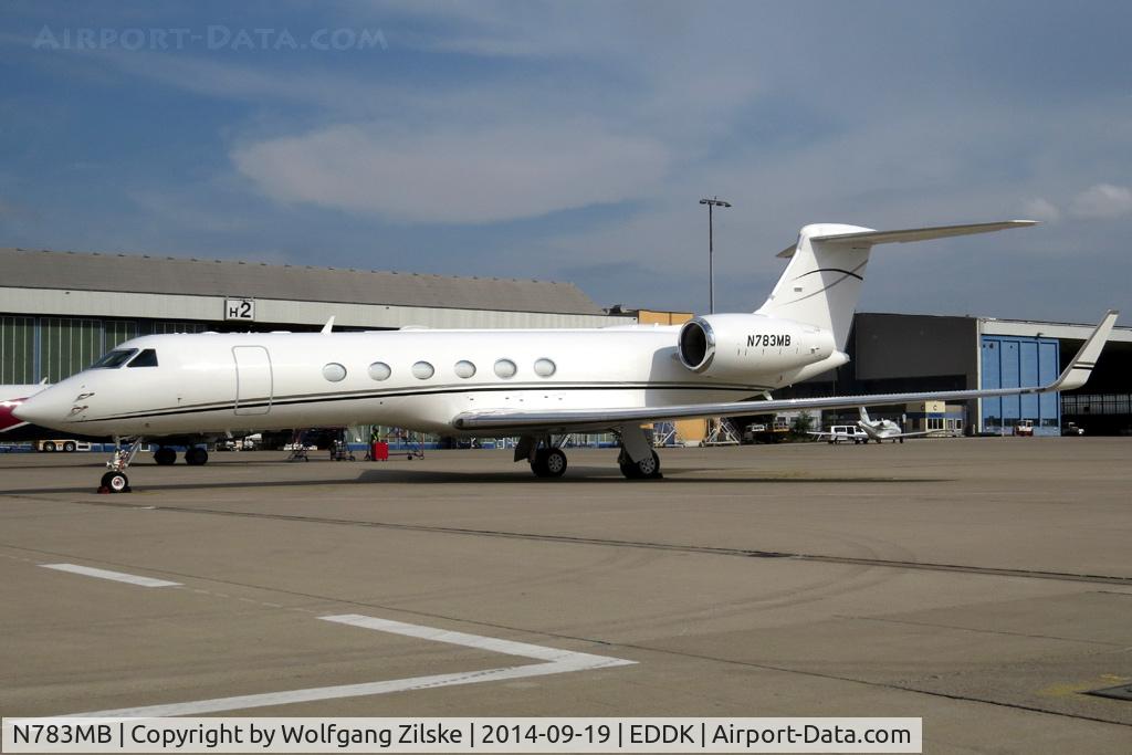
N783MB
MSN
425-0103
Year of Manufacture
1982
Operator
K-AeroDate
August 11, 2021 at 09:00 AM
Type
CRASHFlight Type
Private
Flight Phase
Landing (descent or approach)
Crash Site
Airport (less than 10 km from airport)
Crash Location
Helena Montana
Region
North America • United States of America
Coordinates
46.6336°, -112.0192°
Crash Cause
Technical failure
Narrative Report
On August 11, 2021 at 09:00 AM, Faribault - Missoula experienced a crash involving Cessna 425 Conquest, operated by K-Aero, with the event recorded near Helena Montana.
The flight was categorized as private and the reported phase was landing (descent or approach) at a airport (less than 10 km from airport) crash site.
3 people were known to be on board, 0 fatalities were recorded, 3 survivors were identified or estimated. This corresponds to an estimated fatality rate of 0.0%.
Crew on board: 1, crew fatalities: 0, passengers on board: 2, passenger fatalities: 0, other fatalities: 0.
The listed crash cause is technical failure. On August 11, 2021 about 0900 mountain daylight time, a Cessna 425 Conquest 1, N723MB, sustained substantial damage when it was involved in an accident near Helena, Montana. The pilot and two passengers sustained serious injuries. The airplane was operated as a Title 14 Code of Federal Regulations (CFR) Part 91 business flight. The pilot stated that on the morning of the accident, he physically refueled the airplane to full wing tanks by adding an additional 207 gallons of Jet A. Shortly thereafter, he departed from his home airport in Faribault, Minnesota and continued to his destination at a cruise altitude of 24,000 feet mean sea level. Investigators reviewed Air Traffic Control transmissions and flight track data covering the area of the accident using Federal Aviation Administration (FAA) provided Automatic Dependent SurveillanceBroadcast (ADS-B) data. While en route, at 0847:35, the pilot reported to an air traffic controller that the airplane had an engine flame out and requested a descent. The pilot opted to divert from the originally planned destination and contacted Helena approach control. He stated that the airplane was 16 miles from Helena and descending through 19,000 feet advising the controller that he may need to lose altitude to land on runway 27. The controller responded that the pilot could maneuver north of the airport to then align with the right base leg of the traffic pattern to the runway. At 0852:59 the pilot reported to the air traffic controller that he had an hour and a half of fuel on board and about 3 minutes later the airplane made a right turn to the north. At 0857:15, with the airplane about 7,900 feet msl, the pilot reported that the right engine experienced a loss of power (see Figure 1 below). At 0859:02, the pilot reported the airplane was going to collided with trees. The airplane came to rest with the right wing and empennage severed from the fuselage. The pilot noted that the airplane had undergone an annual inspection in March 2021, equating to about 10 flight hours prior to the accident.
Aircraft reference details include registration N783MB, MSN 425-0103, year of manufacture 1982.
Geospatial coordinates for this crash are approximately 46.6336°, -112.0192°.
Fatalities
Total
0
Crew
0
Passengers
0
Other
0
Crash Summary
On August 11, 2021 about 0900 mountain daylight time, a Cessna 425 Conquest 1, N723MB, sustained substantial damage when it was involved in an accident near Helena, Montana. The pilot and two passengers sustained serious injuries. The airplane was operated as a Title 14 Code of Federal Regulations (CFR) Part 91 business flight. The pilot stated that on the morning of the accident, he physically refueled the airplane to full wing tanks by adding an additional 207 gallons of Jet A. Shortly thereafter, he departed from his home airport in Faribault, Minnesota and continued to his destination at a cruise altitude of 24,000 feet mean sea level. Investigators reviewed Air Traffic Control transmissions and flight track data covering the area of the accident using Federal Aviation Administration (FAA) provided Automatic Dependent SurveillanceBroadcast (ADS-B) data. While en route, at 0847:35, the pilot reported to an air traffic controller that the airplane had an engine flame out and requested a descent. The pilot opted to divert from the originally planned destination and contacted Helena approach control. He stated that the airplane was 16 miles from Helena and descending through 19,000 feet advising the controller that he may need to lose altitude to land on runway 27. The controller responded that the pilot could maneuver north of the airport to then align with the right base leg of the traffic pattern to the runway. At 0852:59 the pilot reported to the air traffic controller that he had an hour and a half of fuel on board and about 3 minutes later the airplane made a right turn to the north. At 0857:15, with the airplane about 7,900 feet msl, the pilot reported that the right engine experienced a loss of power (see Figure 1 below). At 0859:02, the pilot reported the airplane was going to collided with trees. The airplane came to rest with the right wing and empennage severed from the fuselage. The pilot noted that the airplane had undergone an annual inspection in March 2021, equating to about 10 flight hours prior to the accident.
Cause: Technical failure
Occupants & Outcome
Crew On Board
1
Passengers On Board
2
Estimated Survivors
3
Fatality Rate
0.0%
Known people on board: 3
Operational Details
Schedule / Flight
Faribault - Missoula
Operator
K-AeroFlight Type
Private
Flight Phase
Landing (descent or approach)
Crash Site
Airport (less than 10 km from airport)
Region / Country
North America • United States of America
Aircraft Details
Similar Plane Crashes
United States Signal Corps - USSC
De Havilland DH.4
The single engine airplane departed Dayton-McCook Field for a local test flight. Shortly after takeoff, the aircraft stalled and crashed, killing both occupants. Crew: Maj Oscar Brindley, Lt Col Henry Damm.
United States Signal Corps - USSC
De Havilland DH.4
Lt. Frank Stuart Patterson, son and nephew of the co-founders of National Cash Register, is killed in the crash of his DH.4M, AS-32098, at Wilbur Wright Field during a flight test of a new mechanism for synchronizing machine gun and propeller, when a tie rod breaks during a dive from 15,000 feet (4,600 m), causing the wings to separate from the aircraft. Wishing to recognize the contributions of the Patterson family (owners of NCR) the area of Wright Field east of Huffman Dam (including Wilbur Wright Field, Fairfield Air Depot, and the Huffman Prairie) is renamed Patterson Field on 6 July 1931, in honor of Lt. Patterson.
United States Signal Corps - USSC
De Havilland DH.4
The aircraft crashed in unknown circumstances.
United States Signal Corps - USSC
De Havilland DH.4
The crew was completing a training mission. At an altitude of about 4,000 feet, the aircraft entered a spin and crashed in an open field near Everman-Barron Field Airport. A crew was killed and the second occupants was injured. The aircraft was destroyed.
U.S. Air Mail Service
De Havilland DH.4
Crashed following an engine failure. Pilot fate unknown.
United States Signal Corps - USSC
De Havilland DH.4
The accident occurred in unknown circumstances.