George - George
Flight / Schedule
George - George
Aircraft
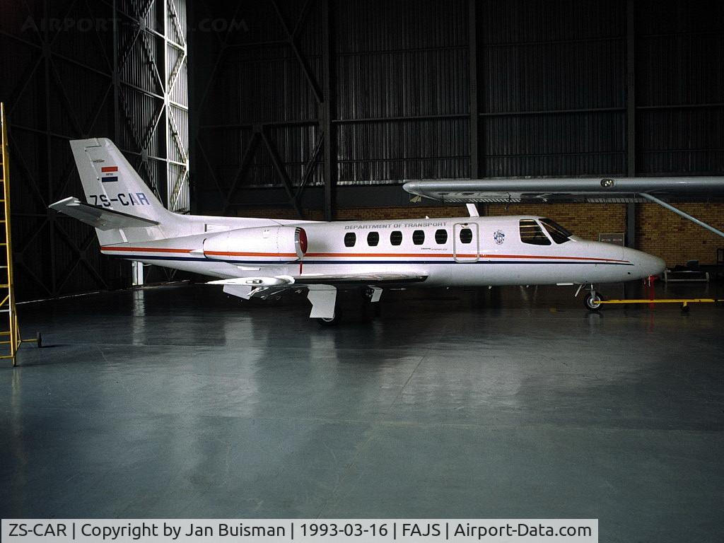
Cessna 550 Citation IIRegistration
ZS-CAR
MSN
S550-0078
Year of Manufacture
1985
Date
January 23, 2020 at 10:50 AM
Type
CRASHFlight Type
Calibration
Flight Phase
Flight
Crash Site
Mountains
Crash Location
George Western Cape
Region
Africa • South Africa
Coordinates
-34.1392°, 22.0871°
Crash Cause
Human factor
Narrative Report
On January 23, 2020 at 10:50 AM, George - George experienced a crash involving Cessna 550 Citation II, operated by South African Civil Aviation Authority, with the event recorded near George Western Cape.
The flight was categorized as calibration and the reported phase was flight at a mountains crash site.
3 people were known to be on board, 3 fatalities were recorded, 0 survivors were identified or estimated. This corresponds to an estimated fatality rate of 100.0%.
Crew on board: 3, crew fatalities: 3, passengers on board: 0, passenger fatalities: 0, other fatalities: 0.
The listed crash cause is human factor. A Cessna S550 Citation S/II of the South African Civil Aviation Authority crashed into the Outeniqua mountains, near the town of Friemersheim. The three occupants were killed and the aircraft was destroyed. The Citation departed Port Elizabeth Airport (FAPE) on a positioning flight to George Airport (FAGG). On approach to FAGG, the flying crew requested to carry out a calibration flight for the very high frequency omnidirectional range (VOR) beacon at FAGG. Due to inclement weather conditions at the time, they were not cleared to conduct VOR calibration. As a result, they decided to land and refuel the aircraft before commencing with the calibration of the Instrument Landing System (ILS) on runway 11 at FAGG. The flying crew requested take-off from runway 11 and an early right turn to intercept radial 250°, 17 nautical miles (nm) DME arc to radial 330° at 3000 feet (ft) climbing to 4,000 feet. The air traffic control (ATC) granted their request. Radar data indicated that at 10:42, the aircraft took off from runway 11 and, once airborne, made a right-hand turn to intercept radial 250° using the George VOR (GRV VOR). The aircraft climbed to 3000ft. Once the aircraft reached 17 nm on the DME from the GRV VOR (DME is co-located with the VOR), it commenced with a right-hand turn to intercept radial 330° while maintaining 17nm DME arc. At 10:46, the ATC at FAGG advised the flying crew that they were now exiting controlled airspace and were advised to broadcast on the special rules frequency. The crew acknowledged the advisory to change frequency and there was no further communication. The aircraft was still being monitored by ATC using secondary surveillance radar. At 10:50, radar data showed the aircraft crossing radial 310° and entered a climb from 3000ft, reaching 3,900 feet. As the aircraft levelled off at 3,900 feet, a rapid descent occurred, and the aircraft lost 1500ft in approximately 9 seconds. Three seconds prior to impact, the aircraft nose pitched up before impacting a ridge at 2,192 feet.
Aircraft reference details include registration ZS-CAR, MSN S550-0078, year of manufacture 1985.
Geospatial coordinates for this crash are approximately -34.1392°, 22.0871°.
Fatalities
Total
3
Crew
3
Passengers
0
Other
0
Crash Summary
A Cessna S550 Citation S/II of the South African Civil Aviation Authority crashed into the Outeniqua mountains, near the town of Friemersheim. The three occupants were killed and the aircraft was destroyed. The Citation departed Port Elizabeth Airport (FAPE) on a positioning flight to George Airport (FAGG). On approach to FAGG, the flying crew requested to carry out a calibration flight for the very high frequency omnidirectional range (VOR) beacon at FAGG. Due to inclement weather conditions at the time, they were not cleared to conduct VOR calibration. As a result, they decided to land and refuel the aircraft before commencing with the calibration of the Instrument Landing System (ILS) on runway 11 at FAGG. The flying crew requested take-off from runway 11 and an early right turn to intercept radial 250°, 17 nautical miles (nm) DME arc to radial 330° at 3000 feet (ft) climbing to 4,000 feet. The air traffic control (ATC) granted their request. Radar data indicated that at 10:42, the aircraft took off from runway 11 and, once airborne, made a right-hand turn to intercept radial 250° using the George VOR (GRV VOR). The aircraft climbed to 3000ft. Once the aircraft reached 17 nm on the DME from the GRV VOR (DME is co-located with the VOR), it commenced with a right-hand turn to intercept radial 330° while maintaining 17nm DME arc. At 10:46, the ATC at FAGG advised the flying crew that they were now exiting controlled airspace and were advised to broadcast on the special rules frequency. The crew acknowledged the advisory to change frequency and there was no further communication. The aircraft was still being monitored by ATC using secondary surveillance radar. At 10:50, radar data showed the aircraft crossing radial 310° and entered a climb from 3000ft, reaching 3,900 feet. As the aircraft levelled off at 3,900 feet, a rapid descent occurred, and the aircraft lost 1500ft in approximately 9 seconds. Three seconds prior to impact, the aircraft nose pitched up before impacting a ridge at 2,192 feet.
Cause: Human factor
Occupants & Outcome
Crew On Board
3
Passengers On Board
0
Estimated Survivors
0
Fatality Rate
100.0%
Known people on board: 3
Operational Details
Schedule / Flight
George - George
Flight Type
Calibration
Flight Phase
Flight
Crash Site
Mountains
Region / Country
Africa • South Africa
Aircraft Details
Similar Plane Crashes
Handley Page Transport
Handley Page O/7
The pilot encountered control problems and elected to make an emergency landing in Acadia Siding. All nine occupants escaped uninjured while the aircraft was damaged beyond repair.
African Aerial Travels
De Havilland DH.60 Moth
While on a flight from Durban, the aircraft crashed in unknown circumstances near Pomeroy. Both occupants were injured and the aircraft was destroyed.
African Aerial Travels
De Havilland DH.60 Moth
Crashed on final approach to Bloemfontein for unknown reason. Both occupants were injured.
Henderson Flying School
Avro 548
Crashed shortly after takeoff from Harrismith, killing both occupants.
Johannesburg Light Plane Club
De Havilland DH.60 Moth
The crew departed Baragwanath Airport on a local training flight. En route, the aircraft entered an uncontrolled descent and crashed in Roodepoort, some 17 km northwest of Johannesburg. Both crew members were injured.
Johannesburg Light Plane Club
De Havilland DH.60 Moth
The crew was completing a local training flight at Baragwanath Airport. The single engine aircraft crashed upon landing for unknown reason. Both occupants were injured.