Newport – East Hampton
Flight / Schedule
Newport – East Hampton
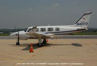
Aircraft
Piper PA-31-350 Navajo ChieftainRegistration
N41173
MSN
31-8452017
Year of Manufacture
1984
Operator
Bernard J. KrupinskiDate
June 2, 2018 at 02:33 PM
Type
CRASHFlight Type
Private
Flight Phase
Landing (descent or approach)
Crash Site
Lake, Sea, Ocean, River
Crash Location
Amagansett New York
Region
North America • United States of America
Coordinates
40.9815°, -72.1332°
Crash Cause
Weather
Narrative Report
On June 2, 2018 at 02:33 PM, Newport – East Hampton experienced a crash involving Piper PA-31-350 Navajo Chieftain, operated by Bernard J. Krupinski, with the event recorded near Amagansett New York.
The flight was categorized as private and the reported phase was landing (descent or approach) at a lake, sea, ocean, river crash site.
4 people were known to be on board, 4 fatalities were recorded, 0 survivors were identified or estimated. This corresponds to an estimated fatality rate of 100.0%.
Crew on board: 1, crew fatalities: 1, passengers on board: 3, passenger fatalities: 3, other fatalities: 0.
The listed crash cause is weather. The commercial pilot of the multiengine airplane was the first of a flight of two airplanes to depart on the cross-country flight, most of which was over the Atlantic Ocean. The pilot of the second airplane stated that he and the accident pilot reviewed the weather for the route and the destination before departing; however, there was no record of the accident pilot receiving an official weather briefing and the information the pilots accessed before the flight could not be determined. The second pilot departed and contacted air traffic control, which advised him of thunderstorms near the destination; he subsequently altered his route of flight and landed uneventfully at the destination. The second pilot stated that he did not hear the accident pilot on the en route air traffic control frequency. Two inflight weather advisories were issued for the route and the area of the destination about 42 and 15 minutes before the accident flight departed, respectively, and warned of heavy to extreme precipitation associated with thunderstorms. It could not be determined whether the accident pilot received these advisories. Review of air traffic control communications and radar data revealed that, about 5 miles from the destination airport, the pilot of the accident airplane reported to the tower controller that he was flying at 700 ft and "coming in below" the thunderstorm. There were no further communications from the pilot. The airplane's last radar target indicated 532 ft about 2 miles south of the shoreline. The airplane was found in about 50 ft of water and was fragmented in several pieces. Postaccident examination revealed no preimpact anomalies with the airplane or engines that would have precluded normal operation. A local resident about 1/2 mile from the accident site took several photos of the approaching thunderstorm, which documented a shelf cloud and cumulus mammatus clouds along the leading edge of the storm, indicative of potential severe turbulence. Review of weather imagery and the airplane's flight path showed that the airplane entered the leading edge of "extreme" intensity echoes with tops near 48,000 ft. Imagery also depicted heavy to extreme intensity radar echoes over the accident site extending to the destination airport. It is likely that the pilot encountered gusting winds, turbulence, restricted visibility in heavy rain, and low cloud ceilings in the vicinity of the accident site and experienced an in-flight loss of control at low altitude. Such conditions are conducive to the development of spatial disorientation; however, the reason for the pilot's loss of control could not be determined based on the available information.
Aircraft reference details include registration N41173, MSN 31-8452017, year of manufacture 1984.
Geospatial coordinates for this crash are approximately 40.9815°, -72.1332°.
Fatalities
Total
4
Crew
1
Passengers
3
Other
0
Crash Summary
The commercial pilot of the multiengine airplane was the first of a flight of two airplanes to depart on the cross-country flight, most of which was over the Atlantic Ocean. The pilot of the second airplane stated that he and the accident pilot reviewed the weather for the route and the destination before departing; however, there was no record of the accident pilot receiving an official weather briefing and the information the pilots accessed before the flight could not be determined. The second pilot departed and contacted air traffic control, which advised him of thunderstorms near the destination; he subsequently altered his route of flight and landed uneventfully at the destination. The second pilot stated that he did not hear the accident pilot on the en route air traffic control frequency. Two inflight weather advisories were issued for the route and the area of the destination about 42 and 15 minutes before the accident flight departed, respectively, and warned of heavy to extreme precipitation associated with thunderstorms. It could not be determined whether the accident pilot received these advisories. Review of air traffic control communications and radar data revealed that, about 5 miles from the destination airport, the pilot of the accident airplane reported to the tower controller that he was flying at 700 ft and "coming in below" the thunderstorm. There were no further communications from the pilot. The airplane's last radar target indicated 532 ft about 2 miles south of the shoreline. The airplane was found in about 50 ft of water and was fragmented in several pieces. Postaccident examination revealed no preimpact anomalies with the airplane or engines that would have precluded normal operation. A local resident about 1/2 mile from the accident site took several photos of the approaching thunderstorm, which documented a shelf cloud and cumulus mammatus clouds along the leading edge of the storm, indicative of potential severe turbulence. Review of weather imagery and the airplane's flight path showed that the airplane entered the leading edge of "extreme" intensity echoes with tops near 48,000 ft. Imagery also depicted heavy to extreme intensity radar echoes over the accident site extending to the destination airport. It is likely that the pilot encountered gusting winds, turbulence, restricted visibility in heavy rain, and low cloud ceilings in the vicinity of the accident site and experienced an in-flight loss of control at low altitude. Such conditions are conducive to the development of spatial disorientation; however, the reason for the pilot's loss of control could not be determined based on the available information.
Cause: Weather
Occupants & Outcome
Crew On Board
1
Passengers On Board
3
Estimated Survivors
0
Fatality Rate
100.0%
Known people on board: 4
Operational Details
Schedule / Flight
Newport – East Hampton
Operator
Bernard J. KrupinskiFlight Type
Private
Flight Phase
Landing (descent or approach)
Crash Site
Lake, Sea, Ocean, River
Region / Country
North America • United States of America
Aircraft Details
Aircraft
Piper PA-31-350 Navajo ChieftainRegistration
N41173
MSN
31-8452017
Year of Manufacture
1984
Similar Plane Crashes
United States Signal Corps - USSC
De Havilland DH.4
The single engine airplane departed Dayton-McCook Field for a local test flight. Shortly after takeoff, the aircraft stalled and crashed, killing both occupants. Crew: Maj Oscar Brindley, Lt Col Henry Damm.
United States Signal Corps - USSC
De Havilland DH.4
Lt. Frank Stuart Patterson, son and nephew of the co-founders of National Cash Register, is killed in the crash of his DH.4M, AS-32098, at Wilbur Wright Field during a flight test of a new mechanism for synchronizing machine gun and propeller, when a tie rod breaks during a dive from 15,000 feet (4,600 m), causing the wings to separate from the aircraft. Wishing to recognize the contributions of the Patterson family (owners of NCR) the area of Wright Field east of Huffman Dam (including Wilbur Wright Field, Fairfield Air Depot, and the Huffman Prairie) is renamed Patterson Field on 6 July 1931, in honor of Lt. Patterson.
United States Signal Corps - USSC
De Havilland DH.4
The aircraft crashed in unknown circumstances.
United States Signal Corps - USSC
De Havilland DH.4
The crew was completing a training mission. At an altitude of about 4,000 feet, the aircraft entered a spin and crashed in an open field near Everman-Barron Field Airport. A crew was killed and the second occupants was injured. The aircraft was destroyed.
U.S. Air Mail Service
De Havilland DH.4
Crashed following an engine failure. Pilot fate unknown.
United States Signal Corps - USSC
De Havilland DH.4
The accident occurred in unknown circumstances.