Saint John’s – Montserrat
Flight / Schedule
Saint John’s – Montserrat
Aircraft
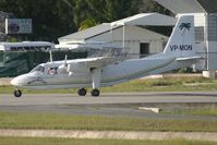
Britten-Norman IslanderRegistration
VP-MON
MSN
82
Year of Manufacture
1969
Operator
Fly MontserratDate
October 7, 2012 at 04:10 PM
Type
CRASHFlight Type
Scheduled Revenue Flight
Flight Phase
Takeoff (climb)
Crash Site
Airport (less than 10 km from airport)
Crash Location
Saint John's-V. C. Bird All Antigua
Region
Central America • Antigua
Crash Cause
Other causes
Narrative Report
On October 7, 2012 at 04:10 PM, Saint John’s – Montserrat experienced a crash involving Britten-Norman Islander, operated by Fly Montserrat, with the event recorded near Saint John's-V. C. Bird All Antigua.
The flight was categorized as scheduled revenue flight and the reported phase was takeoff (climb) at a airport (less than 10 km from airport) crash site.
4 people were known to be on board, 3 fatalities were recorded, 1 survivors were identified or estimated. This corresponds to an estimated fatality rate of 75.0%.
Crew on board: 1, crew fatalities: 1, passengers on board: 3, passenger fatalities: 2, other fatalities: 0.
The listed crash cause is other causes. The aircraft was operating a VFR scheduled commercial air transport flight from VC Bird International Airport, Antigua (TAPA), to John A Osborne Airport, Montserrat (TRPG). The accident occurred during the aircraft’s fourth sector of the day. Prior to the accident flight, another pilot had flown two sectors in it, from John A Osborne to VC Bird and return, before going off duty. The accident pilot reported for duty at 1130 hrs, completed pre-flight preparations, and operated the aircraft to VC Bird. After the aircraft’s arrival at VC Bird, the airport closed to VFR traffic because of cumulonimbus activity and heavy rain. The airport re-opened for VFR operations shortly before the aircraft’s departure. A cumulonimbus cloud was present on the approach to Runway 07, and although the surface wind was westerly, Runway 07 was in use for departures. On board the aircraft were the pilot, three passengers, and bags weighing 150 lb. The fuel load on departure was 65 USG of AVGAS. The takeoff mass was shown on the load sheet as 5,540 lb, which was below the structural maximum takeoff weight of 6,600 lb; the performance-regulated takeoff weight at the ambient temperature of 24 °C was greater than the structural limit. The passengers and pilot travelled in a bus from the airport terminal to the aircraft. The passengers boarded the aircraft, and the baggage was loaded into the compartment behind the rear-most seats. The pilot then boarded the aircraft. The pilot was not observed to carry out a drain of the fuel system’s water traps (the operations manual did not stipulate that a drain check should be carried out). The pilot called the VC Bird Ground Movement Control (GMC) controller for permission to start engines, and was instructed to wait while the controller contacted Montserrat ATC to enquire about the weather there. The pilot then asked for surface wind information for VC Bird and was informed it was from 240° at 10 kts. The controller gave permission for start and passed the Montserrat weather, which was suitable for the operation. The pilot was instructed to taxi to holding position Bravo. The pilot contacted the Tower controller and was instructed to enter, backtrack, and line up on Runway 07. The controller described the weather observed from the Tower to the pilot, and the pilot requested a left-hand turn-out after departure. The surface wind was transmitted as from 270° at 10 kts and the aircraft was cleared for takeoff. The aircraft entered the runway at Bravo but did not backtrack. No power checks were carried out (other evidence indicated that power checks were routinely not carried out other than on each pilot’s first flight of the day). The aircraft took off, and the early part of the climb appeared normal. Analysis of the eye witness reports, and consideration of their locations and fields of view, led to a deduction that this normal climb continued to a height of between 200 and 300 ft above the ground. The aircraft then appeared to ‘sink’, losing a small amount of height without yawing or rolling, before yawing to the right, then rolling to the right, and pitching nose down into an incipient spin to the right. The surviving passenger recalled that the stall warning sounded, and its accompanying red light (which was mounted on the right-hand side of the instrument panel and in his line of sight) illuminated throughout this period and until impact. Witnesses described that the (incipient) spin continued until the aircraft struck the ground. ATC staff in the visual control room activated the airport’s crash alarm. The rescue and fire-fighting service (RFFS) responded promptly from their station; the crew of one RFFS vehicle, working on the airport, observed the accident and responded directly to it. The pilot and one passenger were fatally injured on impact. Another passenger succumbed to her injuries before she could be extricated from the wreckage, and the third passenger, who had sustained serious injuries, was taken to hospital.
Aircraft reference details include registration VP-MON, MSN 82, year of manufacture 1969.
Fatalities
Total
3
Crew
1
Passengers
2
Other
0
Crash Summary
The aircraft was operating a VFR scheduled commercial air transport flight from VC Bird International Airport, Antigua (TAPA), to John A Osborne Airport, Montserrat (TRPG). The accident occurred during the aircraft’s fourth sector of the day. Prior to the accident flight, another pilot had flown two sectors in it, from John A Osborne to VC Bird and return, before going off duty. The accident pilot reported for duty at 1130 hrs, completed pre-flight preparations, and operated the aircraft to VC Bird. After the aircraft’s arrival at VC Bird, the airport closed to VFR traffic because of cumulonimbus activity and heavy rain. The airport re-opened for VFR operations shortly before the aircraft’s departure. A cumulonimbus cloud was present on the approach to Runway 07, and although the surface wind was westerly, Runway 07 was in use for departures. On board the aircraft were the pilot, three passengers, and bags weighing 150 lb. The fuel load on departure was 65 USG of AVGAS. The takeoff mass was shown on the load sheet as 5,540 lb, which was below the structural maximum takeoff weight of 6,600 lb; the performance-regulated takeoff weight at the ambient temperature of 24 °C was greater than the structural limit. The passengers and pilot travelled in a bus from the airport terminal to the aircraft. The passengers boarded the aircraft, and the baggage was loaded into the compartment behind the rear-most seats. The pilot then boarded the aircraft. The pilot was not observed to carry out a drain of the fuel system’s water traps (the operations manual did not stipulate that a drain check should be carried out). The pilot called the VC Bird Ground Movement Control (GMC) controller for permission to start engines, and was instructed to wait while the controller contacted Montserrat ATC to enquire about the weather there. The pilot then asked for surface wind information for VC Bird and was informed it was from 240° at 10 kts. The controller gave permission for start and passed the Montserrat weather, which was suitable for the operation. The pilot was instructed to taxi to holding position Bravo. The pilot contacted the Tower controller and was instructed to enter, backtrack, and line up on Runway 07. The controller described the weather observed from the Tower to the pilot, and the pilot requested a left-hand turn-out after departure. The surface wind was transmitted as from 270° at 10 kts and the aircraft was cleared for takeoff. The aircraft entered the runway at Bravo but did not backtrack. No power checks were carried out (other evidence indicated that power checks were routinely not carried out other than on each pilot’s first flight of the day). The aircraft took off, and the early part of the climb appeared normal. Analysis of the eye witness reports, and consideration of their locations and fields of view, led to a deduction that this normal climb continued to a height of between 200 and 300 ft above the ground. The aircraft then appeared to ‘sink’, losing a small amount of height without yawing or rolling, before yawing to the right, then rolling to the right, and pitching nose down into an incipient spin to the right. The surviving passenger recalled that the stall warning sounded, and its accompanying red light (which was mounted on the right-hand side of the instrument panel and in his line of sight) illuminated throughout this period and until impact. Witnesses described that the (incipient) spin continued until the aircraft struck the ground. ATC staff in the visual control room activated the airport’s crash alarm. The rescue and fire-fighting service (RFFS) responded promptly from their station; the crew of one RFFS vehicle, working on the airport, observed the accident and responded directly to it. The pilot and one passenger were fatally injured on impact. Another passenger succumbed to her injuries before she could be extricated from the wreckage, and the third passenger, who had sustained serious injuries, was taken to hospital.
Cause: Other causes
Occupants & Outcome
Crew On Board
1
Passengers On Board
3
Estimated Survivors
1
Fatality Rate
75.0%
Known people on board: 4
Operational Details
Schedule / Flight
Saint John’s – Montserrat
Operator
Fly MontserratFlight Type
Scheduled Revenue Flight
Flight Phase
Takeoff (climb)
Crash Site
Airport (less than 10 km from airport)
Region / Country
Central America • Antigua
Aircraft Details
Similar Plane Crashes
Britten-Norman
Britten-Norman Islander
The prototype aircraft, after having carried out several demonstration flights in Germany, was on its way back to England. It took off from Emden, Germany, at 1137 hrs local time on a non-scheduled international VFR flight to Southampton, England, with the pilot and one passenger. Two minutes after take-off the aircraft made radio contact with Eelde and at 1150 hrs informed Eelde that it was "abeam Eelde VOR" and flying at 1 500 ft VMC on top of cloud. At this position the aircraft could not have had any visual ground contact. At 1156 hrs the aircraft asked Amsterdam Flight Information Service for radar assistance in order to pass through Schiphol Control Zone but was informed it was not possible because positive radar contact could not be established. At 1209 hrs the aircraft was advised to divert to Eelde because weather conditions in the Schiphol Control Zone precluded VFR flight through the zone at 1500 ft. On receipt of this information the pilot informed Amsterdam that he would proceed according to his flight plan. At 1220 hrs when flying at 1 500 ft the pilot informed Schiphol that he would clear Schiphol Control Zone to the west. This was after the controller had positively instructed him to remain clear of the Control Zone and that it was impossible to pass through the zone at 1 500 ft under VFR. Reconstruction of the aircraft's flight path showed that at about 1225 hrs it deviated from its route and cleared the Schiphol area on a heading of about 040°. Shortly afterwards, at 1234 hrs the pilot reported he vas experiencing "serious compass trouble1' and asked for a "steer" but Amsterdam still had no radar contact with the aircraft. According to eyewitnesses, the aircraft was, at about this time, flying at a very low height around the vicinity of the village of Rijs, returning to or passing over the same area several times. It was also established from these witnesses that the weather conditions were such i.e. fog and rain, that the pilot would not have had adequate visual reference. At 1240 hrs the pilot reported "some compass trouble" and again requested radar guidance but radar contact had still not been established. Flight at low altitude was apparently discontinued at about 1247 hrs and at 1249 hrs the pilot reported at 3 000 ft in IMC and that he had a serious instrument failure. Schiphol Control instructed him to maintain FL 30 (3 000 ft) and a heading of 200'. Contrary to this instruction, the pilot reported at 1251 hrs as being at FL 50 and at 1254 hrs at 6 000 ft. At 1255 hrs the controller asked if the aircraft was circling, the pilot replied in the affirmative and said "I think I am going around it". The controller acknowledged this transmission and remarked that he thought the aircraft should be heading 200°; the pilot then replied "I cannot maintain a heading". At that moment the aircraft was positively identified on the radar screen. Replying to the radar controller's instruction to fly specific headings and to make a left-hand turn the pilot said he could not maintain a heading and that right hand turns were easier to mase. At 1258 hrs the pilot requested the height of cloud tops and inquired if there were any clear layers in which he could find visual flight conditions. At his request he was cleared to climb to FL 80; however, a German military aircraft which had recently flown over Spijkerboor at PL 100 reported that it had been "fully IMC" there. At 1301 hrs the pilot reported at 8 700 ft and "climbing as fast as I can, I want to pet out on top"; this was the last recognizable transmission heard by Schiphol. The aircraft was observed on the radar screen until about 1309 hrs at which time radar contact was lost. According to the radar controller the indications observed on the screen for the last 10 to 12 minutes indicated that the aircraft made a series of random small radius right and left-hand turns. At 1310 hrs witnesses near Ringwiel lake saw parts of an aircraft falling, most of it into the lake; these were later identified as parts of the subject aircraft. Calculations and evidence suggested that the aircraft climbed to an altitude above 10 000 ft where it would have encountered severe icing and would have reached a region of moderate to severe turbulence. The time of impact was estimated to be approximately 1310 hrs. The aircraft was totally destroyed and both occupants were killed.
Aerovias del Valle
Britten-Norman Islander
While approaching Paso Canoas Airstrip on a flight from San José, the twin engine airplane went out of control and crashed in the mouth of the Rio Grande de Terraba, about 7 km west of the airfield. The aircraft was destroyed and all 10 occupants were killed.
General Airlines
Britten-Norman Islander
On final approach to Narsarsuaq Airport, the twin engine aircraft was too low and crashed few km short of runway. The pilot was injured and the aircraft was destroyed. He was supposed to deliver the aircraft to the US.
Sud Aviación
Britten-Norman Islander
Crashed in unknown circumstances somewhere in Argentina. No casualties.
San Juan Air
Britten-Norman Islander
En route from Fort Lauderdale to San Juan via Great Inagua, the airplane crashed into the Sargasso Sea in unknown circumstances. There was no distress call sent by the pilot en route. SAR operations were conducted but eventually suspended few days later as no trace of the aircraft nor both occupants was found.
Aerial Tours
Britten-Norman Islander
Crashed in unknown circumstances. No casualties.