Bamaga – Lockhart River – Cairns
Flight / Schedule
Bamaga – Lockhart River – Cairns
Aircraft
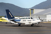
Swearingen SA227 Metro IIIRegistration
VH-TFU
MSN
DC-818B
Year of Manufacture
1992
Operator
Aero-Tropics Air ServicesDate
May 7, 2005 at 11:44 AM
Type
CRASHFlight Type
Scheduled Revenue Flight
Flight Phase
Landing (descent or approach)
Crash Site
Mountains
Crash Location
Lockhart River Queensland
Region
Oceania • Australia
Coordinates
-13.0453°, 143.3050°
Crash Cause
Human factor
Narrative Report
On May 7, 2005 at 11:44 AM, Bamaga – Lockhart River – Cairns experienced a crash involving Swearingen SA227 Metro III, operated by Aero-Tropics Air Services, with the event recorded near Lockhart River Queensland.
The flight was categorized as scheduled revenue flight and the reported phase was landing (descent or approach) at a mountains crash site.
15 people were known to be on board, 15 fatalities were recorded, 0 survivors were identified or estimated. This corresponds to an estimated fatality rate of 100.0%.
Crew on board: 2, crew fatalities: 2, passengers on board: 13, passenger fatalities: 13, other fatalities: 0.
The listed crash cause is human factor. On 7 May 2005, a Fairchild Aircraft Inc. SA227DC Metro 23 aircraft, registered VH-TFU, with two pilots and 13 passengers, was being operated by Transair on an instrument flight rules (IFR) regular public transport (RPT) service from Bamaga to Cairns, with an intermediate stop at Lockhart River, Queensland. At 1143:39 Eastern Standard Time, the aircraft impacted terrain in the Iron Range National Park on the north-western slope of South Pap, a heavily timbered ridge, approximately 11 km north-west of the Lockhart River aerodrome. At the time of the accident, the crew was conducting an area navigation global navigation satellite system (RNAV (GNSS)) non-precision approach to runway 12. The aircraft was destroyed by the impact forces and an intense, fuel-fed, post-impact fire. There were no survivors. The accident was almost certainly the result of controlled flight into terrain; that is, an airworthy aircraft under the control of the flight crew was flown unintentionally into terrain, probably with no prior awareness by the crew of the aircraft’s proximity to terrain. Weather conditions in the Lockhart River area were poor and necessitated the conduct of an instrument approach procedure for an intended landing at the aerodrome. The cloud base was probably between 500 ft and 1,000 ft above mean sea level and the terrain to the west of the aerodrome, beneath the runway 12 RNAV (GNSS) approach, was probably obscured by cloud. The flight data recorder (FDR) data showed that, during the entire descent and approach, the aircraft engine and flight control system parameters were normal and that the crew were accurately navigating the aircraft along the instrument approach track. The FDR data and wreckage examination showed that the aircraft was configured for the approach, with the landing gear down and flaps extended to the half position. There were no radio broadcasts made by the crew on the air traffic services frequencies or the Lockhart River common traffic advisory frequency indicating that there was a problem with the aircraft or crew.
Aircraft reference details include registration VH-TFU, MSN DC-818B, year of manufacture 1992.
Geospatial coordinates for this crash are approximately -13.0453°, 143.3050°.
Fatalities
Total
15
Crew
2
Passengers
13
Other
0
Crash Summary
On 7 May 2005, a Fairchild Aircraft Inc. SA227DC Metro 23 aircraft, registered VH-TFU, with two pilots and 13 passengers, was being operated by Transair on an instrument flight rules (IFR) regular public transport (RPT) service from Bamaga to Cairns, with an intermediate stop at Lockhart River, Queensland. At 1143:39 Eastern Standard Time, the aircraft impacted terrain in the Iron Range National Park on the north-western slope of South Pap, a heavily timbered ridge, approximately 11 km north-west of the Lockhart River aerodrome. At the time of the accident, the crew was conducting an area navigation global navigation satellite system (RNAV (GNSS)) non-precision approach to runway 12. The aircraft was destroyed by the impact forces and an intense, fuel-fed, post-impact fire. There were no survivors. The accident was almost certainly the result of controlled flight into terrain; that is, an airworthy aircraft under the control of the flight crew was flown unintentionally into terrain, probably with no prior awareness by the crew of the aircraft’s proximity to terrain. Weather conditions in the Lockhart River area were poor and necessitated the conduct of an instrument approach procedure for an intended landing at the aerodrome. The cloud base was probably between 500 ft and 1,000 ft above mean sea level and the terrain to the west of the aerodrome, beneath the runway 12 RNAV (GNSS) approach, was probably obscured by cloud. The flight data recorder (FDR) data showed that, during the entire descent and approach, the aircraft engine and flight control system parameters were normal and that the crew were accurately navigating the aircraft along the instrument approach track. The FDR data and wreckage examination showed that the aircraft was configured for the approach, with the landing gear down and flaps extended to the half position. There were no radio broadcasts made by the crew on the air traffic services frequencies or the Lockhart River common traffic advisory frequency indicating that there was a problem with the aircraft or crew.
Cause: Human factor
Occupants & Outcome
Crew On Board
2
Passengers On Board
13
Estimated Survivors
0
Fatality Rate
100.0%
Known people on board: 15
Operational Details
Schedule / Flight
Bamaga – Lockhart River – Cairns
Operator
Aero-Tropics Air ServicesFlight Type
Scheduled Revenue Flight
Flight Phase
Landing (descent or approach)
Crash Site
Mountains
Region / Country
Oceania • Australia
Aircraft Details
Similar Plane Crashes
Royal Australian Air Force - RAAF
Avro 504
The crew was performing a training flight out from Point Cook. Shortly after takeoff, while climbing to an altitude of 500 feet, the aircraft dove into the ground and crashed, bursting into flames. One pilot was killed instantly while the second one died few hours later. This was the first accident involving an aircraft of the Royal Australian Air Force which was officially founded a week ago on March 31, 1921. Crew: Lt James Fryer-Smith, pilot Cpl Bertie W. Whicker, mechanic.
Western Australia Airways
Bristol Tourer
The crew was performing the inaugural flight from Geraldton to Derby which was considered as the first commercial flight within Australia. On approach to Kalbarri, the aircraft crashed for unknown reasons near the Murchinson River, killing both occupants. Crew: Ted Broad, Bob Fawcett.
O. Ramsay
Avro 504
During the takeoff roll, the pilot swerved the airplane to avoid two boys running across the runway. He lost control of the airplane that crashed near the beach. The aircraft was destroyed and all three occupants were injured.
Qantas Airways - Queensland and Northern Territory Aerial Services
Armstrong Whitworth F.K.8
Crashed on takeoff for unknown reasons. While the aircraft was damaged beyond repair, there were no casualties.
Qantas Airways - Queensland and Northern Territory Aerial Services
Armstrong Whitworth F.K.8
En route from Charleville to Longreach, the pilot encountered technical problems and elected to make an emergency landing in Blackall. While the pilot was uninjured, the aircraft was damaged beyond repair.
Royal Australian Air Force - RAAF
Avro 504
The pilot was performing a night training flight at Point Cook Airport. On final approach, he lost control of the aircraft that crashed near the airport. The pilot was injured and the aircraft was damaged beyond repair.