Herat - Kabul
Flight / Schedule
Herat - Kabul
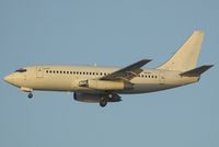
Aircraft
Boeing 737-200Registration
EX-037
MSN
22075
Year of Manufacture
1980
Operator
Kam AirDate
February 3, 2005 at 03:15 PM
Type
CRASHFlight Type
Scheduled Revenue Flight
Flight Phase
Flight
Crash Site
Mountains
Crash Location
Kabul Kabul
Region
Asia • Afghanistan
Coordinates
34.4619°, 69.1197°
Crash Cause
Human factor
Narrative Report
On February 3, 2005 at 03:15 PM, Herat - Kabul experienced a crash involving Boeing 737-200, operated by Kam Air, with the event recorded near Kabul Kabul.
The flight was categorized as scheduled revenue flight and the reported phase was flight at a mountains crash site.
105 people were known to be on board, 105 fatalities were recorded, 0 survivors were identified or estimated. This corresponds to an estimated fatality rate of 100.0%.
Crew on board: 8, crew fatalities: 8, passengers on board: 97, passenger fatalities: 97, other fatalities: 0.
The listed crash cause is human factor. On February 3, 2005, a Boeing 737-242 aircraft (the "Aircraft") with Kyrgyz Republic registration EX-037, operated by Phoenix Aviation, was conducting Kam Air Flight 904 from Herat to Kabul. There were a total of 105 occupants on board the Aircraft, including eight crew members and ninety-seven passengers. The Aircraft was cruising at flight level 270 when it contacted Bagram Radar Approach Control ("Bagram") for descent and landing. The flight was normal until it failed to level at flight level 130 during the VOR/DME approach. At 1043:24 UTC, Bagram cleared the flight to descend at its discretion and to expect the VOR approach to runway 29. The prevailing weather was also passed on to the Aircraft. Visibility was reported 2 kilometers with snow, ceiling 2,200 feet broken. wind calm and altimeter setting QNH 1016. AT 1043:58 UTC, when the Aircraft was 35 miles west of the Kabul VOR. radar contact was established with Ba9ram. The Aircraft was advised by Bagram to cross the VOR at or above flight level 130 and cleared it for the VOR/DME approach to runway 29. At 1048:41 UTC the Aircraft reported flight level 130. Bagram again cleared the Aircraft for the VOR approach to runway 29 and advised the Aircraft to report procedure turn inbound. The crew replied that they would report proceeding inbound for the VOR approach to runway 29. This was the last transmission from the Aircraft. At about 1050:11 UTC, Bagram stated that radar contact had been lost with the Aircraft. Bagram and Kabul Air Traffic Control Tower attempted to locate the Aircraft through radar and radio communication, but were not successful. Search for the Aircraft was delayed and hampered due to a severe snowstorm in the region. The Aircraft was located approximately three days later by an International Security Assistance Force (ISAF) helicopter approximately 30 kilometers southeast of Kabul International Airport at N 36 27.900 E 69 30.185. The Aircraft was destroyed by force of impact from colliding with the mountain. All 105 occupants on board the Aircraft had received fatal injuries. Subsequently, all bodies were recovered and identified. The wreckage was found at the altitude of 9,960 feet (3,035 metres) on the summit of Mt Shapiri Ghar located about 30 km southeast of Kabul Airport.
Aircraft reference details include registration EX-037, MSN 22075, year of manufacture 1980.
Geospatial coordinates for this crash are approximately 34.4619°, 69.1197°.
Fatalities
Total
105
Crew
8
Passengers
97
Other
0
Crash Summary
On February 3, 2005, a Boeing 737-242 aircraft (the "Aircraft") with Kyrgyz Republic registration EX-037, operated by Phoenix Aviation, was conducting Kam Air Flight 904 from Herat to Kabul. There were a total of 105 occupants on board the Aircraft, including eight crew members and ninety-seven passengers. The Aircraft was cruising at flight level 270 when it contacted Bagram Radar Approach Control ("Bagram") for descent and landing. The flight was normal until it failed to level at flight level 130 during the VOR/DME approach. At 1043:24 UTC, Bagram cleared the flight to descend at its discretion and to expect the VOR approach to runway 29. The prevailing weather was also passed on to the Aircraft. Visibility was reported 2 kilometers with snow, ceiling 2,200 feet broken. wind calm and altimeter setting QNH 1016. AT 1043:58 UTC, when the Aircraft was 35 miles west of the Kabul VOR. radar contact was established with Ba9ram. The Aircraft was advised by Bagram to cross the VOR at or above flight level 130 and cleared it for the VOR/DME approach to runway 29. At 1048:41 UTC the Aircraft reported flight level 130. Bagram again cleared the Aircraft for the VOR approach to runway 29 and advised the Aircraft to report procedure turn inbound. The crew replied that they would report proceeding inbound for the VOR approach to runway 29. This was the last transmission from the Aircraft. At about 1050:11 UTC, Bagram stated that radar contact had been lost with the Aircraft. Bagram and Kabul Air Traffic Control Tower attempted to locate the Aircraft through radar and radio communication, but were not successful. Search for the Aircraft was delayed and hampered due to a severe snowstorm in the region. The Aircraft was located approximately three days later by an International Security Assistance Force (ISAF) helicopter approximately 30 kilometers southeast of Kabul International Airport at N 36 27.900 E 69 30.185. The Aircraft was destroyed by force of impact from colliding with the mountain. All 105 occupants on board the Aircraft had received fatal injuries. Subsequently, all bodies were recovered and identified. The wreckage was found at the altitude of 9,960 feet (3,035 metres) on the summit of Mt Shapiri Ghar located about 30 km southeast of Kabul Airport.
Cause: Human factor
Occupants & Outcome
Crew On Board
8
Passengers On Board
97
Estimated Survivors
0
Fatality Rate
100.0%
Known people on board: 105
Operational Details
Schedule / Flight
Herat - Kabul
Operator
Kam AirFlight Type
Scheduled Revenue Flight
Flight Phase
Flight
Crash Site
Mountains
Region / Country
Asia • Afghanistan
Aircraft Details
Similar Plane Crashes
Iran Air
Douglas C-47 Skytrain (DC-3)
Flight IR123 was a scheduled international cargo flight from Kabul, Afghanistan to Tehran, Iran. The co-pilot was in the left-hand seat and pilot flying at the commencement of the takeoff run. The aircraft was cleared for takeoff on runway 29 at 13:13. When accelerating for takeoff the pilot-in-command noticed that the propeller of the no. 1 engine was overspeeding and surging as high as 3300 rpm. As the aircraft approached an indicated airspeed of about 80 kts the captain took command. He noticed that the aircraft was headed to the left away from the runway centreline towards three runway lights in a concrete footing at the left edge of the runway. To avoid a possible collision with these lights the captain applied elevator control and lifted the aircraft off the runway. The overspeeding propeller condition did not subside although he followed the procedure prescribed in the operations manual for corrective action. The flight path was about 30 to 45° to the left of the runway and in the general direction of the Kabul Airport terminal building so the captain attempted to turn the aircraft further to the left to avoid collision with the building. About 325 ft from the south edge of runway 29 the left wing contacted the ground and the aircraft crashed.
TMA of Lebanon - Trans Mediterranean Airways
Douglas C-54 Skymaster
The aircraft was on a non-scheduled international cargo flight from Beirut, Lebanon to Kabul, Afghanistan via Kuwait, carrying a crew of three. The trip to Kuwait was uneventful, and it arrived there at 0036 hours GMT on 12 December. Departure from Kuwait for Kabul was at 0256 hours and the flight reported passing Kandahar at 0838 and Kalat at 0900 flying at flight level 110. While en route the aircraft was provided with the Kandahar and Kabul weather. At 0942 hours it reported passing Ghazni at 0940, flying at flight level 150 and estimated its arrival time at Kabul as 10 10 hours. However, at 0958 (i. e. 12 minutes before ETA) it reported overhead Kabul and requested the latest weather situation which was provided. As the aircraft could not land at Kabul because of the weather conditions it reported at 0959 hours that it was diverting to Lahore. Shortly thereafter it reported it was proceeding to Zahedan via Ghazni (ETA 1025), Kandahar (ETA 1130) Zahedan (ETA 13 15). It would maintain flight level 150 to Ghazni, 130 to Kandahar and 110 to Zahedan. At 1003 hours the Kabul tower passed the Kandahar weather to the flight and 5 minutes later the flight reported it was 25 miles out from Kabul, at flight level 150. The aircraft was then cleared by Kabul tower to route frequency and nothing further was heard from it. The wreckage of the aircraft was first sighted on 16 August 1964, after the snow had melted, at an elevation of 13 940 ft amsl in the Koh-i-Safid Mountains 50 NM west of Ghazni and 42 NM from the approved air route. The coordinates of the accident site were estimated to be 33° 37' N 67° 35' E. The time of the accident was some time after 1015 hours GMT on 12 December 1963. The wreckage was found by Afghan soldiers on 16 August 1964.
Ariana Afghan Airlines
Douglas DC-3
Crashed in unknown circumstances in a mountainous area located in the Logar Province. The exact date of the mishap remains unknown. The airplane crashed sometime in the year 1963.
Ariana Afghan Airlines
Douglas C-47 Skytrain (DC-3)
Two Ariana Afghan Airlines aircraft collided in unknown circumstances at Kabul Airport. A C-47 registered YA-AAB was damaged beyond repair while a DC-6 registered YA-DAN was repaired. There were no injuries.
United Airlines
Boeing 737-200
At 18:50 Boeing 737 "City of Bristol" taxied to runway 09 for departure. At 19:05 the first officer, who was pilot flying, initiated the takeoff roll. Shortly after rotation, at a speed above V2, a loud bang was heard and the aircraft veered to the right. The captain moved both throttles forward but there seemed to be no response. The captain then made the instantaneous decision to set the aircraft back on the runway. The aircraft touched down 1075 feet short of the runway end. The 737 continued of the end of the runway and across the blast pad. It crossed a field, passed through a 6-foot high aluminum chain link fence into an area covered with high grass, weeds and brush. The aircraft came to rest 1634 feet past the end of the runway.
Bakhtar Afghan Airlines
Yakovlev Yak-40
On final approach to Khost Airport, the crew failed to realize his altitude was too low. On short final, the three engine airplane struck tree tops located 154 meters short of runway 24 threshold. After impact, the airplane lost height and landed hard. The crew was able to stop the aircraft normally and as there were no injuries, the aircraft was considered as damaged beyond repair.