Albuquerque International Airport, NM (ABQ/KABQ) → Chinle Municipal Airport, AZ (E91)
Flight / Schedule
Albuquerque International Airport, NM (ABQ/KABQ) → Chinle Municipal Airport, AZ (E91)
Aircraft
Beechcraft 300 Super King AirRegistration
N534AW
MSN
FA-154
Year of Manufacture
1988
Operator
CSI Aviation IncDate
August 5, 2025 at 12:00 AM
Type
CRASHFlight Type
Ambulance
Flight Phase
Landing
Crash Site
Destroyed
Crash Location
Chinle Municipal Airport (E91), Chinle, AZ -
Region
United States of America
Coordinates
36.1144°, -109.5780°
Narrative Report
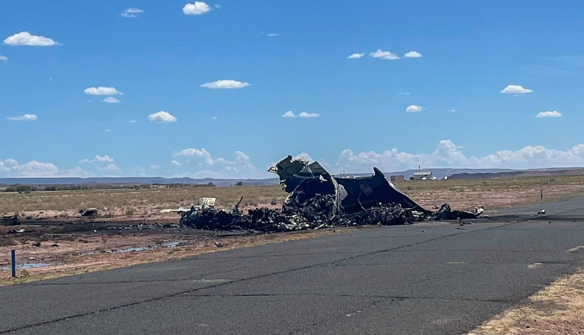
On August 5, 2025 at 12:00 AM, Albuquerque International Airport, NM (ABQ/KABQ) → Chinle Municipal Airport, AZ (E91) experienced a crash involving Beechcraft 300 Super King Air, operated by CSI Aviation Inc, with the event recorded near Chinle Municipal Airport (E91), Chinle, AZ -.
The flight was categorized as ambulance and the reported phase was landing at a destroyed crash site.
4 fatalities were recorded, 0 survivors were identified or estimated.
other fatalities: 0.
On August 5, 2025, about 1245 mountain daylight time, a Beech 300, N534AW, was destroyed when it was involved in an accident near Chinle, Arizona. The pilot, co-pilot and two medical crew members were fatally injured. The airplane was operated as a Title 14 Code of Federal Regulations Part 135 positioning flight. Automatic dependent surveillance-broadcast (ADS-B) data and air traffic control radar data showed that the airplane departed Albuquerque International Sunport Airport (ABQ) Albuquerque, New Mexico about 1155, climbed to 18,000 ft mean sea level (msl) and proceeded direct to Chinle Municipal Airport (E91) Chinle, Arizona. About 1229 the airplane began a descent and about 1239, the airplane entered the traffic pattern on the downwind leg for runway 36. About 1240, while about 6,600 ft, the airplane turned right and entered the base leg. The last radar data point recorded the airplane about 6,100 ft, and about 2.8 miles southeast of the runway 36 threshold. According to a witness, who was located about one quarter mile from the airport, he observed the airplane on a northbound heading over the runway while flying about 180 ft above ground level (agl). The left wing banked erratically multiple times and then leveled off, at which time the airplane pitched up. The left wing then dropped into a knife edge attitude, while the airplane descended to the ground and immediately erupted in flames. The airplane impacted open terrain about 990 ft west of runway 36 at an elevation of about 5,510 ft. A path of disturbed terrain and vegetation extended about 281 ft from the main wreckage and included multiple airframe components. A postaccident fire thermally damaged the fuselage and wings. A cockpit voice recorder was recovered from the airplane and shipped to the NTSB Vehicle Recorders Laboratory for download. The airplane was recovered to a secure facility for further examination.
Aircraft reference details include registration N534AW, MSN FA-154, year of manufacture 1988.
Geospatial coordinates for this crash are approximately 36.1144°, -109.5780°.
Fatalities
Total
4
Crew
0
Passengers
0
Other
0
Crash Summary
On August 5, 2025, about 1245 mountain daylight time, a Beech 300, N534AW, was destroyed when it was involved in an accident near Chinle, Arizona. The pilot, co-pilot and two medical crew members were fatally injured. The airplane was operated as a Title 14 Code of Federal Regulations Part 135 positioning flight. Automatic dependent surveillance-broadcast (ADS-B) data and air traffic control radar data showed that the airplane departed Albuquerque International Sunport Airport (ABQ) Albuquerque, New Mexico about 1155, climbed to 18,000 ft mean sea level (msl) and proceeded direct to Chinle Municipal Airport (E91) Chinle, Arizona. About 1229 the airplane began a descent and about 1239, the airplane entered the traffic pattern on the downwind leg for runway 36. About 1240, while about 6,600 ft, the airplane turned right and entered the base leg. The last radar data point recorded the airplane about 6,100 ft, and about 2.8 miles southeast of the runway 36 threshold. According to a witness, who was located about one quarter mile from the airport, he observed the airplane on a northbound heading over the runway while flying about 180 ft above ground level (agl). The left wing banked erratically multiple times and then leveled off, at which time the airplane pitched up. The left wing then dropped into a knife edge attitude, while the airplane descended to the ground and immediately erupted in flames. The airplane impacted open terrain about 990 ft west of runway 36 at an elevation of about 5,510 ft. A path of disturbed terrain and vegetation extended about 281 ft from the main wreckage and included multiple airframe components. A postaccident fire thermally damaged the fuselage and wings. A cockpit voice recorder was recovered from the airplane and shipped to the NTSB Vehicle Recorders Laboratory for download. The airplane was recovered to a secure facility for further examination.
Occupants & Outcome
Crew On Board
—
Passengers On Board
—
Estimated Survivors
0
Fatality Rate
—
Operational Details
Schedule / Flight
Albuquerque International Airport, NM (ABQ/KABQ) → Chinle Municipal Airport, AZ (E91)
Operator
CSI Aviation IncFlight Type
Ambulance
Flight Phase
Landing
Crash Site
Destroyed
Region / Country
United States of America
Aircraft Details
Similar Plane Crashes
United States Signal Corps - USSC
De Havilland DH.4
The single engine airplane departed Dayton-McCook Field for a local test flight. Shortly after takeoff, the aircraft stalled and crashed, killing both occupants. Crew: Maj Oscar Brindley, Lt Col Henry Damm.
United States Signal Corps - USSC
De Havilland DH.4
Lt. Frank Stuart Patterson, son and nephew of the co-founders of National Cash Register, is killed in the crash of his DH.4M, AS-32098, at Wilbur Wright Field during a flight test of a new mechanism for synchronizing machine gun and propeller, when a tie rod breaks during a dive from 15,000 feet (4,600 m), causing the wings to separate from the aircraft. Wishing to recognize the contributions of the Patterson family (owners of NCR) the area of Wright Field east of Huffman Dam (including Wilbur Wright Field, Fairfield Air Depot, and the Huffman Prairie) is renamed Patterson Field on 6 July 1931, in honor of Lt. Patterson.
United States Signal Corps - USSC
De Havilland DH.4
The aircraft crashed in unknown circumstances.
United States Signal Corps - USSC
De Havilland DH.4
The crew was completing a training mission. At an altitude of about 4,000 feet, the aircraft entered a spin and crashed in an open field near Everman-Barron Field Airport. A crew was killed and the second occupants was injured. The aircraft was destroyed.
U.S. Air Mail Service
De Havilland DH.4
Crashed following an engine failure. Pilot fate unknown.
United States Signal Corps - USSC
De Havilland DH.4
The accident occurred in unknown circumstances.