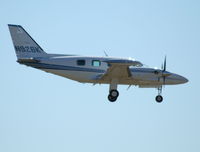
N926K
Flight / Schedule
N926K
Aircraft
Piper PA-31 CheyenneRegistration
N926K
MSN
31-8004046
Year of Manufacture
1980
Operator
FMR AviationDate
April 20, 2020 at 09:50 AM
Type
CRASHFlight Type
Private
Flight Phase
Takeoff (climb)
Crash Site
Airport (less than 10 km from airport)
Crash Location
Billings-Logan Montana
Region
North America • United States of America
Coordinates
45.8092°, -108.5477°
Narrative Report
On April 20, 2020 at 09:50 AM, N926K experienced a crash involving Piper PA-31 Cheyenne, operated by FMR Aviation, with the event recorded near Billings-Logan Montana.
The flight was categorized as private and the reported phase was takeoff (climb) at a airport (less than 10 km from airport) crash site.
1 people were known to be on board, 1 fatalities were recorded, 0 survivors were identified or estimated. This corresponds to an estimated fatality rate of 100.0%.
Crew on board: 1, crew fatalities: 1, passengers on board: 0, passenger fatalities: 0, other fatalities: 0.
On April 20, 2020 about 0950 mountain daylight time, a Piper PA-31T1 airplane, N926K, was destroyed when it was involved in an accident about 1-1/2 miles west of Billings Logan International Airport (BIL), Billings, Montana. The airline transport pilot was fatally injured. The airplane was operated as a Title 14 Code of Federal Regulations Part 91 local flight. According to ATC information, the pilot requested to taxi to runway 28L for takeoff, and then perform pattern work, and land on runway 28R at BIL. After the pilot held short of runway 28L, the controller cleared the pilot for takeoff with instructions to extend the upwind leg. Shortly after takeoff, the pilot was instructed to enter the left traffic pattern for runway 28R twice, with no response. A subsequent attempt was made to establish communication, with no response. About a minute and a half after the airplane departed, a column of smoke was observed west of the airport. Radar data showed the airplane departing runway 28L and remaining on runway centerline heading for the length of the flight. The airplane's altitude climbed to about 100 ft above ground level and the airplane's groundspeed increased to 81 knots soon after departure, and then decreased to 70 knots before dropping off radar. Witnesses located near the departure end of runway 28L watched the airplane through a window, depart the runway with its gear not retracted. The airplane was lower than normal as it neared the end of the runway. All the witnesses moved outside to watch as the airplane flew away from their location. One of the witnesses stated that the airplane had a "slow descent trajectory and a slight-nose up attitude." The airplane passed over a hill and out of view. None of the witness reportedly saw the accident sequence but saw the column of smoke rising from the accident site. Another witness who was sitting in his vehicle near the accident site saw the airplane pass about 250 ft in front of his position. The airplane's wings were level and the landing gear was up when it struck the ground. He lost sight of the airplane as it flew into a nearby coulee. Ground scars found near the top of a coulee consisted of the airplane's fuselage impact mark and symmetrical propeller strikes consistent with the airplane impacting the ground in a shallow, nose-up, wings-level attitude. The airplane then continued over the coulee about 410 ft, and about 75 ft down before impacting the side of the coulee where a postimpact fire ensued. All major structural components of the airplane were located within the debris field.
Aircraft reference details include registration N926K, MSN 31-8004046, year of manufacture 1980.
Geospatial coordinates for this crash are approximately 45.8092°, -108.5477°.
Fatalities
Total
1
Crew
1
Passengers
0
Other
0
Crash Summary
On April 20, 2020 about 0950 mountain daylight time, a Piper PA-31T1 airplane, N926K, was destroyed when it was involved in an accident about 1-1/2 miles west of Billings Logan International Airport (BIL), Billings, Montana. The airline transport pilot was fatally injured. The airplane was operated as a Title 14 Code of Federal Regulations Part 91 local flight. According to ATC information, the pilot requested to taxi to runway 28L for takeoff, and then perform pattern work, and land on runway 28R at BIL. After the pilot held short of runway 28L, the controller cleared the pilot for takeoff with instructions to extend the upwind leg. Shortly after takeoff, the pilot was instructed to enter the left traffic pattern for runway 28R twice, with no response. A subsequent attempt was made to establish communication, with no response. About a minute and a half after the airplane departed, a column of smoke was observed west of the airport. Radar data showed the airplane departing runway 28L and remaining on runway centerline heading for the length of the flight. The airplane's altitude climbed to about 100 ft above ground level and the airplane's groundspeed increased to 81 knots soon after departure, and then decreased to 70 knots before dropping off radar. Witnesses located near the departure end of runway 28L watched the airplane through a window, depart the runway with its gear not retracted. The airplane was lower than normal as it neared the end of the runway. All the witnesses moved outside to watch as the airplane flew away from their location. One of the witnesses stated that the airplane had a "slow descent trajectory and a slight-nose up attitude." The airplane passed over a hill and out of view. None of the witness reportedly saw the accident sequence but saw the column of smoke rising from the accident site. Another witness who was sitting in his vehicle near the accident site saw the airplane pass about 250 ft in front of his position. The airplane's wings were level and the landing gear was up when it struck the ground. He lost sight of the airplane as it flew into a nearby coulee. Ground scars found near the top of a coulee consisted of the airplane's fuselage impact mark and symmetrical propeller strikes consistent with the airplane impacting the ground in a shallow, nose-up, wings-level attitude. The airplane then continued over the coulee about 410 ft, and about 75 ft down before impacting the side of the coulee where a postimpact fire ensued. All major structural components of the airplane were located within the debris field.
Occupants & Outcome
Crew On Board
1
Passengers On Board
0
Estimated Survivors
0
Fatality Rate
100.0%
Known people on board: 1
Operational Details
Operator
FMR AviationFlight Type
Private
Flight Phase
Takeoff (climb)
Crash Site
Airport (less than 10 km from airport)
Region / Country
North America • United States of America
Aircraft Details
Similar Plane Crashes
United States Signal Corps - USSC
De Havilland DH.4
The single engine airplane departed Dayton-McCook Field for a local test flight. Shortly after takeoff, the aircraft stalled and crashed, killing both occupants. Crew: Maj Oscar Brindley, Lt Col Henry Damm.
United States Signal Corps - USSC
De Havilland DH.4
Lt. Frank Stuart Patterson, son and nephew of the co-founders of National Cash Register, is killed in the crash of his DH.4M, AS-32098, at Wilbur Wright Field during a flight test of a new mechanism for synchronizing machine gun and propeller, when a tie rod breaks during a dive from 15,000 feet (4,600 m), causing the wings to separate from the aircraft. Wishing to recognize the contributions of the Patterson family (owners of NCR) the area of Wright Field east of Huffman Dam (including Wilbur Wright Field, Fairfield Air Depot, and the Huffman Prairie) is renamed Patterson Field on 6 July 1931, in honor of Lt. Patterson.
United States Signal Corps - USSC
De Havilland DH.4
The aircraft crashed in unknown circumstances.
United States Signal Corps - USSC
De Havilland DH.4
The crew was completing a training mission. At an altitude of about 4,000 feet, the aircraft entered a spin and crashed in an open field near Everman-Barron Field Airport. A crew was killed and the second occupants was injured. The aircraft was destroyed.
U.S. Air Mail Service
De Havilland DH.4
Crashed following an engine failure. Pilot fate unknown.
United States Signal Corps - USSC
De Havilland DH.4
The accident occurred in unknown circumstances.