Talkeetna - Talkeetna
Flight / Schedule
Talkeetna - Talkeetna
Aircraft
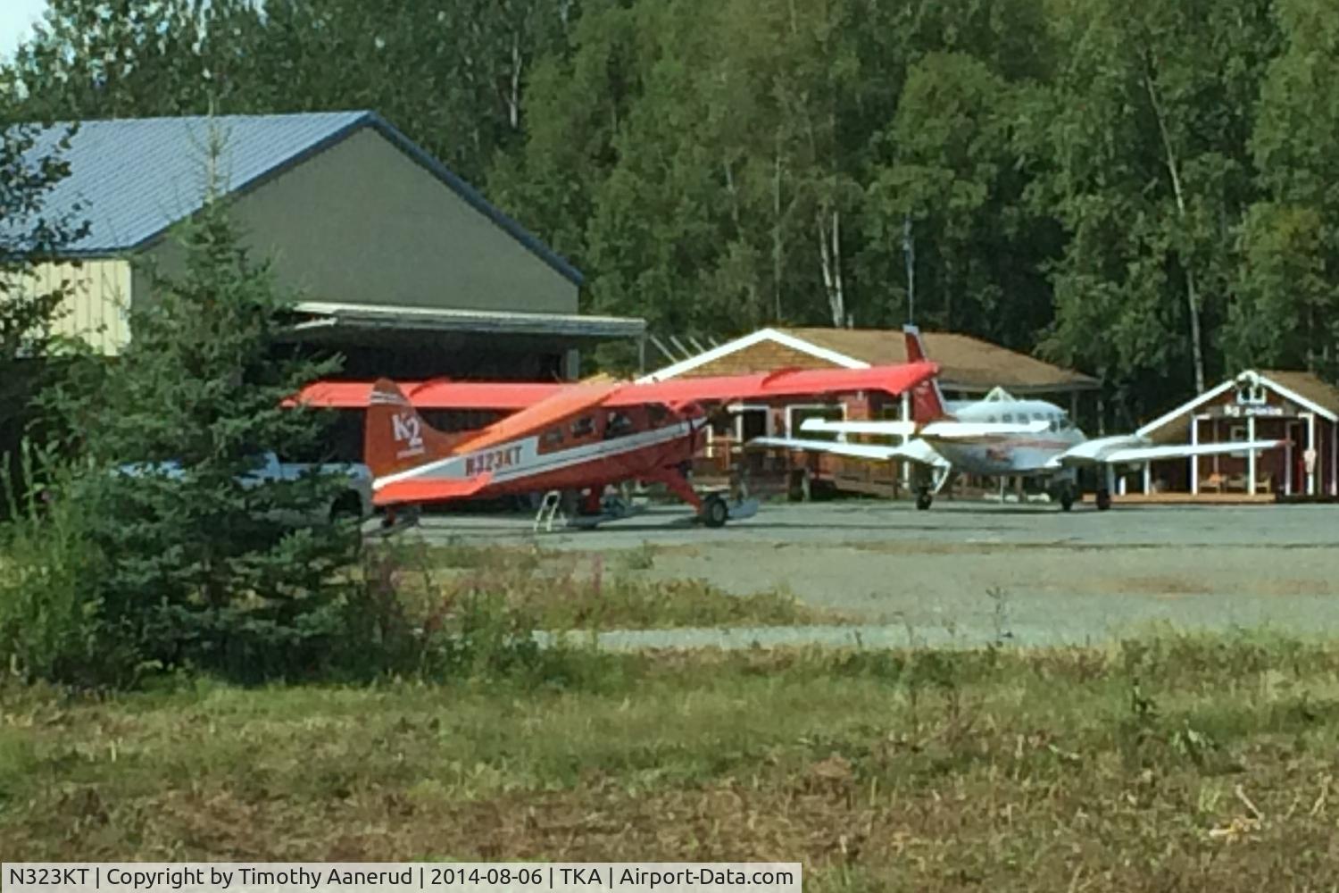
De Havilland DHC-2 BeaverRegistration
N323KT
MSN
1022
Year of Manufacture
1957
Operator
K2 AviationDate
August 4, 2018 at 05:53 PM
Type
CRASHFlight Type
Charter/Taxi (Non Scheduled Revenue Flight)
Flight Phase
Flight
Crash Site
Mountains
Crash Location
Mt Kahiltna Alaska
Region
North America • United States of America
Narrative Report
On August 4, 2018 at 05:53 PM, Talkeetna - Talkeetna experienced a crash involving De Havilland DHC-2 Beaver, operated by K2 Aviation, with the event recorded near Mt Kahiltna Alaska.
The flight was categorized as charter/taxi (non scheduled revenue flight) and the reported phase was flight at a mountains crash site.
5 people were known to be on board, 5 fatalities were recorded, 0 survivors were identified or estimated. This corresponds to an estimated fatality rate of 100.0%.
Crew on board: 1, crew fatalities: 1, passengers on board: 4, passenger fatalities: 4, other fatalities: 0.
The commercial pilot was conducting a 1-hour commercial air tour flight over Denali National Park and Preserve with four passengers on board. About 48 minutes after departure, the Alaska Rescue Coordination Center received an alert from the airplane's emergency locator transmitter. About 7 minutes later, company personnel received a call from the pilot, who reported that the airplane had run "into the side of a mountain." Although a search was initiated almost immediately, due to poor weather conditions in the area, the wreckage was not located until almost 36 hours later in a crevasse on a glacier about 10,920 ft mean sea level. Due to the unique challenges posed by the steepness of terrain, the crevasse, avalanche hazard, and the condition of the airplane, neither the occupants nor the wreckage were recovered from the accident site. A weather model sounding for the area of the accident site estimated broken cloud bases at 700 ft above ground level (agl) with overcast clouds at 1,000 ft agl and cloud tops to 21,000 ft agl and higher clouds above. The freezing level was at 9,866 ft and supported light-to-moderate rime type icing in clouds and precipitation. The on-scene assessment indicated that the right wing impacted snow while the airplane was flying in a wings-level attitude; the right wing had separated from the remainder of the wreckage. Based upon available weather data and forecast models and the impact evidence, it is likely that the pilot entered an area of reduced visibility and was unable to see the terrain before the airplane's right wing impacted the snow. The company's organizational structure was such that one group of management personnel oversaw operations in both Anchorage and Talkeetna. Interviews with company management revealed that they were not always aware of the exact routing a pilot would take for a tour; the route was pilot's discretion based upon the weather at the time of the flight to provide the best tour experience. Regarding risk mitigation, the company did not utilize a formal risk assessment process, but rather relied on conversations between pilots and flight followers. This could lead to an oversight of actual risk associated with a particular flight route and weather conditions. About 8 months after the accident, an assessment flight conducted by the National Park Service determined that during the winter, the hazardous hanging glacier at the accident site calved, releasing an estimated 4,000 to 6,000 tons of ice and debris. There was no evidence of the airplane wreckage near the crash site, in the steep fall line, or on the glacier surface over 3,600 ft below. Although the known circumstances of the accident are consistent with a controlled flight into terrain event, the factual information available was limited because the wreckage was not recovered and no autopsy or toxicology of the pilot could be performed; therefore, whether other circumstances may have contributed to the accident could not be determined.
Aircraft reference details include registration N323KT, MSN 1022, year of manufacture 1957.
Fatalities
Total
5
Crew
1
Passengers
4
Other
0
Crash Summary
The commercial pilot was conducting a 1-hour commercial air tour flight over Denali National Park and Preserve with four passengers on board. About 48 minutes after departure, the Alaska Rescue Coordination Center received an alert from the airplane's emergency locator transmitter. About 7 minutes later, company personnel received a call from the pilot, who reported that the airplane had run "into the side of a mountain." Although a search was initiated almost immediately, due to poor weather conditions in the area, the wreckage was not located until almost 36 hours later in a crevasse on a glacier about 10,920 ft mean sea level. Due to the unique challenges posed by the steepness of terrain, the crevasse, avalanche hazard, and the condition of the airplane, neither the occupants nor the wreckage were recovered from the accident site. A weather model sounding for the area of the accident site estimated broken cloud bases at 700 ft above ground level (agl) with overcast clouds at 1,000 ft agl and cloud tops to 21,000 ft agl and higher clouds above. The freezing level was at 9,866 ft and supported light-to-moderate rime type icing in clouds and precipitation. The on-scene assessment indicated that the right wing impacted snow while the airplane was flying in a wings-level attitude; the right wing had separated from the remainder of the wreckage. Based upon available weather data and forecast models and the impact evidence, it is likely that the pilot entered an area of reduced visibility and was unable to see the terrain before the airplane's right wing impacted the snow. The company's organizational structure was such that one group of management personnel oversaw operations in both Anchorage and Talkeetna. Interviews with company management revealed that they were not always aware of the exact routing a pilot would take for a tour; the route was pilot's discretion based upon the weather at the time of the flight to provide the best tour experience. Regarding risk mitigation, the company did not utilize a formal risk assessment process, but rather relied on conversations between pilots and flight followers. This could lead to an oversight of actual risk associated with a particular flight route and weather conditions. About 8 months after the accident, an assessment flight conducted by the National Park Service determined that during the winter, the hazardous hanging glacier at the accident site calved, releasing an estimated 4,000 to 6,000 tons of ice and debris. There was no evidence of the airplane wreckage near the crash site, in the steep fall line, or on the glacier surface over 3,600 ft below. Although the known circumstances of the accident are consistent with a controlled flight into terrain event, the factual information available was limited because the wreckage was not recovered and no autopsy or toxicology of the pilot could be performed; therefore, whether other circumstances may have contributed to the accident could not be determined.
Occupants & Outcome
Crew On Board
1
Passengers On Board
4
Estimated Survivors
0
Fatality Rate
100.0%
Known people on board: 5
Operational Details
Schedule / Flight
Talkeetna - Talkeetna
Operator
K2 AviationFlight Type
Charter/Taxi (Non Scheduled Revenue Flight)
Flight Phase
Flight
Crash Site
Mountains
Region / Country
North America • United States of America
Aircraft Details
Similar Plane Crashes
United States Signal Corps - USSC
De Havilland DH.4
The single engine airplane departed Dayton-McCook Field for a local test flight. Shortly after takeoff, the aircraft stalled and crashed, killing both occupants. Crew: Maj Oscar Brindley, Lt Col Henry Damm.
United States Signal Corps - USSC
De Havilland DH.4
Lt. Frank Stuart Patterson, son and nephew of the co-founders of National Cash Register, is killed in the crash of his DH.4M, AS-32098, at Wilbur Wright Field during a flight test of a new mechanism for synchronizing machine gun and propeller, when a tie rod breaks during a dive from 15,000 feet (4,600 m), causing the wings to separate from the aircraft. Wishing to recognize the contributions of the Patterson family (owners of NCR) the area of Wright Field east of Huffman Dam (including Wilbur Wright Field, Fairfield Air Depot, and the Huffman Prairie) is renamed Patterson Field on 6 July 1931, in honor of Lt. Patterson.
United States Signal Corps - USSC
De Havilland DH.4
The aircraft crashed in unknown circumstances.
United States Signal Corps - USSC
De Havilland DH.4
The crew was completing a training mission. At an altitude of about 4,000 feet, the aircraft entered a spin and crashed in an open field near Everman-Barron Field Airport. A crew was killed and the second occupants was injured. The aircraft was destroyed.
U.S. Air Mail Service
De Havilland DH.4
Crashed following an engine failure. Pilot fate unknown.
United States Signal Corps - USSC
De Havilland DH.4
The accident occurred in unknown circumstances.