Millington – Spruce Creek
Flight / Schedule
Millington – Spruce Creek
Aircraft
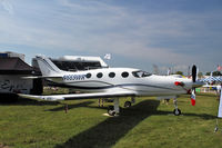
Epic LTRegistration
N669WR
MSN
029
Year of Manufacture
2009
Operator
Independent TechnologiesDate
December 27, 2016 at 05:56 PM
Type
CRASHFlight Type
Private
Flight Phase
Landing (descent or approach)
Crash Site
City
Crash Location
Spruce Creek Florida
Region
North America • United States of America
Coordinates
29.0931°, -81.0172°
Crash Cause
Human factor
Narrative Report
On December 27, 2016 at 05:56 PM, Millington – Spruce Creek experienced a crash involving Epic LT, operated by Independent Technologies, with the event recorded near Spruce Creek Florida.
The flight was categorized as private and the reported phase was landing (descent or approach) at a city crash site.
2 people were known to be on board, 2 fatalities were recorded, 0 survivors were identified or estimated. This corresponds to an estimated fatality rate of 100.0%.
Crew on board: 1, crew fatalities: 1, passengers on board: 1, passenger fatalities: 1, other fatalities: 0.
The listed crash cause is human factor. The private pilot obtained a full weather briefing before departing on a long cross-country flight. The destination airport was forecast to be under visual meteorological conditions, but there was an AIRMET and Center Weather Advisory (CWA) issued for low instrument flight rules (IFR) conditions later that day. The briefer told the pilot to check the weather again en route to see if the AIRMET and CWA had been updated. At the time the pilot stopped for fuel, another CWA was issued for low IFR conditions at his destination airport; however, there were no records to indicate that the pilot obtained this information during the fuel stop or after departing on the last leg of the flight. A review of air traffic control communications revealed that, about 10 minutes before arriving at the airport, the pilot reported that he had obtained the current weather conditions at his destination airport. The most recent observation, about 1 hour before the accident indicated good visibility; however, the weather reporting equipment did not provide ceiling heights. It is unknown if the pilot obtained weather information from nearby airports, which were reporting low instrument meteorological conditions (visibility between 1/4 and 1/2 mile and ceilings 200-300 ft above ground level [agl]). Additionally, three pilot reports (PIREPs) describing the poor weather conditions were filed within the hour before the accident. The controller did not relay the PIREPs or the CWA information to the pilot, so the pilot was likely unaware of the deteriorating conditions. Based on radar information and statements from witnesses, the pilot's approach to the airport was unstabilized. He descended below the minimum descent altitude of 440 ft, and, after breaking through the fog about 100 ft agl, the airplane reentered the fog and completed a 360° right turn near the approach end of the runway, during which its altitude varied from 100 ft to 300 ft. The airplane then climbed to an altitude about 800 ft before radar contact was lost near the accident site. The airplane came to rest inverted, consistent with one witness's statement that it descended through the clouds in a spin before impact; post accident examination revealed no preimpact anomalies with the airplane or engine that would have precluded normal operation. Although the pilot was instrument rated, his recent instrument experience could not be established. The circumstances of the accident, including the restricted visibility conditions and the pilot's maneuvering of the airplane before the impact, are consistent with a spatial disorientation event. It is likely that the pilot experienced a loss of control due to spatial disorientation, which resulted in an aerodynamic stall and spin.
Aircraft reference details include registration N669WR, MSN 029, year of manufacture 2009.
Geospatial coordinates for this crash are approximately 29.0931°, -81.0172°.
Fatalities
Total
2
Crew
1
Passengers
1
Other
0
Crash Summary
The private pilot obtained a full weather briefing before departing on a long cross-country flight. The destination airport was forecast to be under visual meteorological conditions, but there was an AIRMET and Center Weather Advisory (CWA) issued for low instrument flight rules (IFR) conditions later that day. The briefer told the pilot to check the weather again en route to see if the AIRMET and CWA had been updated. At the time the pilot stopped for fuel, another CWA was issued for low IFR conditions at his destination airport; however, there were no records to indicate that the pilot obtained this information during the fuel stop or after departing on the last leg of the flight. A review of air traffic control communications revealed that, about 10 minutes before arriving at the airport, the pilot reported that he had obtained the current weather conditions at his destination airport. The most recent observation, about 1 hour before the accident indicated good visibility; however, the weather reporting equipment did not provide ceiling heights. It is unknown if the pilot obtained weather information from nearby airports, which were reporting low instrument meteorological conditions (visibility between 1/4 and 1/2 mile and ceilings 200-300 ft above ground level [agl]). Additionally, three pilot reports (PIREPs) describing the poor weather conditions were filed within the hour before the accident. The controller did not relay the PIREPs or the CWA information to the pilot, so the pilot was likely unaware of the deteriorating conditions. Based on radar information and statements from witnesses, the pilot's approach to the airport was unstabilized. He descended below the minimum descent altitude of 440 ft, and, after breaking through the fog about 100 ft agl, the airplane reentered the fog and completed a 360° right turn near the approach end of the runway, during which its altitude varied from 100 ft to 300 ft. The airplane then climbed to an altitude about 800 ft before radar contact was lost near the accident site. The airplane came to rest inverted, consistent with one witness's statement that it descended through the clouds in a spin before impact; post accident examination revealed no preimpact anomalies with the airplane or engine that would have precluded normal operation. Although the pilot was instrument rated, his recent instrument experience could not be established. The circumstances of the accident, including the restricted visibility conditions and the pilot's maneuvering of the airplane before the impact, are consistent with a spatial disorientation event. It is likely that the pilot experienced a loss of control due to spatial disorientation, which resulted in an aerodynamic stall and spin.
Cause: Human factor
Occupants & Outcome
Crew On Board
1
Passengers On Board
1
Estimated Survivors
0
Fatality Rate
100.0%
Known people on board: 2
Operational Details
Schedule / Flight
Millington – Spruce Creek
Operator
Independent TechnologiesFlight Type
Private
Flight Phase
Landing (descent or approach)
Crash Site
City
Region / Country
North America • United States of America
Aircraft Details
Similar Plane Crashes
United States Signal Corps - USSC
De Havilland DH.4
The single engine airplane departed Dayton-McCook Field for a local test flight. Shortly after takeoff, the aircraft stalled and crashed, killing both occupants. Crew: Maj Oscar Brindley, Lt Col Henry Damm.
United States Signal Corps - USSC
De Havilland DH.4
Lt. Frank Stuart Patterson, son and nephew of the co-founders of National Cash Register, is killed in the crash of his DH.4M, AS-32098, at Wilbur Wright Field during a flight test of a new mechanism for synchronizing machine gun and propeller, when a tie rod breaks during a dive from 15,000 feet (4,600 m), causing the wings to separate from the aircraft. Wishing to recognize the contributions of the Patterson family (owners of NCR) the area of Wright Field east of Huffman Dam (including Wilbur Wright Field, Fairfield Air Depot, and the Huffman Prairie) is renamed Patterson Field on 6 July 1931, in honor of Lt. Patterson.
United States Signal Corps - USSC
De Havilland DH.4
The aircraft crashed in unknown circumstances.
United States Signal Corps - USSC
De Havilland DH.4
The crew was completing a training mission. At an altitude of about 4,000 feet, the aircraft entered a spin and crashed in an open field near Everman-Barron Field Airport. A crew was killed and the second occupants was injured. The aircraft was destroyed.
U.S. Air Mail Service
De Havilland DH.4
Crashed following an engine failure. Pilot fate unknown.
United States Signal Corps - USSC
De Havilland DH.4
The accident occurred in unknown circumstances.