Washington County – State College
Flight / Schedule
Washington County – State College
Aircraft
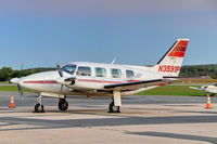
Piper PA-31-310 NavajoRegistration
N3591P
MSN
31-8012081
Year of Manufacture
1980
Operator
Aero NationalDate
June 16, 2016 at 08:30 AM
Type
CRASHFlight Type
Ambulance
Flight Phase
Landing (descent or approach)
Crash Site
Airport (less than 10 km from airport)
Crash Location
State College-University Park Pennsylvania
Region
North America • United States of America
Coordinates
40.8129°, -77.8711°
Crash Cause
Human factor
Narrative Report
On June 16, 2016 at 08:30 AM, Washington County – State College experienced a crash involving Piper PA-31-310 Navajo, operated by Aero National, with the event recorded near State College-University Park Pennsylvania.
The flight was categorized as ambulance and the reported phase was landing (descent or approach) at a airport (less than 10 km from airport) crash site.
2 people were known to be on board, 2 fatalities were recorded, 0 survivors were identified or estimated. This corresponds to an estimated fatality rate of 100.0%.
Crew on board: 1, crew fatalities: 1, passengers on board: 1, passenger fatalities: 1, other fatalities: 0.
The listed crash cause is human factor. The commercial pilot was completing an instrument flight rules air taxi flight on a route that he had flown numerous times for the customer on board. Radar and voice communication data revealed that the airplane was vectored to the final approach course for the precision approach and was given a radio frequency change to the destination airport control tower frequency. The tower controller issued a landing clearance, which the pilot acknowledged; there were no further communications with the pilot. Weather conditions at the airport at the time of the accident included an overcast ceiling at 300 ft with 1 mile visibility in mist. The wreckage was located in densely-wooded terrain. Postaccident examination revealed no evidence of any mechanical malfunctions or anomalies that would have precluded normal operation. The wreckage path and evidence of engine power displayed by numerous cut tree branches was consistent with a controlled, wings-level descent with power. A radar performance study revealed that, as the airplane crossed the precision final approach fix 6.7 nautical miles (nm) from the runway threshold, the airplane was 800 ft above the glideslope. At the outer marker, 5.5 nm from the runway threshold, the airplane was 500 ft above the glideslope. When radar contact was lost 3.2 nm from the threshold, the airplane was about 250 ft above the glideslope. Although the airplane remained within the lateral limits of the approach localizer, its last two recorded radar returns would have correlated with a full downward deflection of the glideslope indicator in the cockpit, and therefore, an unstabilized approach. Further interpolation of radar data revealed that, during the last 2 minutes of the accident flight, the airplane's rate of descent increased from 400 ft per minute (fpm) to greater than 1,700 fpm, likely as a result of pilot inputs. During the final minute of the flight, the rate decreased briefly to 1,000 fpm before radar contact was lost. The company's standard operating procedures stated that, if a rate of descent greater than 1,000 fpm was encountered during an instrument approach, a missed approach should be performed. The airplane's relative position to the glideslope and its rapid changes in descent rate after crossing the outer marker suggest that the airplane never met the operator's stabilized approach criteria. Rather than executing a missed approach procedure as outlined in the company's operating procedures, the pilot chose to continue the unstabilized approach, which resulted in a descent into trees and terrain. It is unlikely that the pilot's well-controlled diabetes and effectively treated sleep apnea contributed to the circumstances of this accident. However, whether or not the pilot's multiple sclerosis contributed to this accident could not be determined.
Aircraft reference details include registration N3591P, MSN 31-8012081, year of manufacture 1980.
Geospatial coordinates for this crash are approximately 40.8129°, -77.8711°.
Fatalities
Total
2
Crew
1
Passengers
1
Other
0
Crash Summary
The commercial pilot was completing an instrument flight rules air taxi flight on a route that he had flown numerous times for the customer on board. Radar and voice communication data revealed that the airplane was vectored to the final approach course for the precision approach and was given a radio frequency change to the destination airport control tower frequency. The tower controller issued a landing clearance, which the pilot acknowledged; there were no further communications with the pilot. Weather conditions at the airport at the time of the accident included an overcast ceiling at 300 ft with 1 mile visibility in mist. The wreckage was located in densely-wooded terrain. Postaccident examination revealed no evidence of any mechanical malfunctions or anomalies that would have precluded normal operation. The wreckage path and evidence of engine power displayed by numerous cut tree branches was consistent with a controlled, wings-level descent with power. A radar performance study revealed that, as the airplane crossed the precision final approach fix 6.7 nautical miles (nm) from the runway threshold, the airplane was 800 ft above the glideslope. At the outer marker, 5.5 nm from the runway threshold, the airplane was 500 ft above the glideslope. When radar contact was lost 3.2 nm from the threshold, the airplane was about 250 ft above the glideslope. Although the airplane remained within the lateral limits of the approach localizer, its last two recorded radar returns would have correlated with a full downward deflection of the glideslope indicator in the cockpit, and therefore, an unstabilized approach. Further interpolation of radar data revealed that, during the last 2 minutes of the accident flight, the airplane's rate of descent increased from 400 ft per minute (fpm) to greater than 1,700 fpm, likely as a result of pilot inputs. During the final minute of the flight, the rate decreased briefly to 1,000 fpm before radar contact was lost. The company's standard operating procedures stated that, if a rate of descent greater than 1,000 fpm was encountered during an instrument approach, a missed approach should be performed. The airplane's relative position to the glideslope and its rapid changes in descent rate after crossing the outer marker suggest that the airplane never met the operator's stabilized approach criteria. Rather than executing a missed approach procedure as outlined in the company's operating procedures, the pilot chose to continue the unstabilized approach, which resulted in a descent into trees and terrain. It is unlikely that the pilot's well-controlled diabetes and effectively treated sleep apnea contributed to the circumstances of this accident. However, whether or not the pilot's multiple sclerosis contributed to this accident could not be determined.
Cause: Human factor
Occupants & Outcome
Crew On Board
1
Passengers On Board
1
Estimated Survivors
0
Fatality Rate
100.0%
Known people on board: 2
Operational Details
Schedule / Flight
Washington County – State College
Operator
Aero NationalFlight Type
Ambulance
Flight Phase
Landing (descent or approach)
Crash Site
Airport (less than 10 km from airport)
Region / Country
North America • United States of America
Aircraft Details
Similar Plane Crashes
United States Signal Corps - USSC
De Havilland DH.4
The single engine airplane departed Dayton-McCook Field for a local test flight. Shortly after takeoff, the aircraft stalled and crashed, killing both occupants. Crew: Maj Oscar Brindley, Lt Col Henry Damm.
United States Signal Corps - USSC
De Havilland DH.4
Lt. Frank Stuart Patterson, son and nephew of the co-founders of National Cash Register, is killed in the crash of his DH.4M, AS-32098, at Wilbur Wright Field during a flight test of a new mechanism for synchronizing machine gun and propeller, when a tie rod breaks during a dive from 15,000 feet (4,600 m), causing the wings to separate from the aircraft. Wishing to recognize the contributions of the Patterson family (owners of NCR) the area of Wright Field east of Huffman Dam (including Wilbur Wright Field, Fairfield Air Depot, and the Huffman Prairie) is renamed Patterson Field on 6 July 1931, in honor of Lt. Patterson.
United States Signal Corps - USSC
De Havilland DH.4
The aircraft crashed in unknown circumstances.
United States Signal Corps - USSC
De Havilland DH.4
The crew was completing a training mission. At an altitude of about 4,000 feet, the aircraft entered a spin and crashed in an open field near Everman-Barron Field Airport. A crew was killed and the second occupants was injured. The aircraft was destroyed.
U.S. Air Mail Service
De Havilland DH.4
Crashed following an engine failure. Pilot fate unknown.
United States Signal Corps - USSC
De Havilland DH.4
The accident occurred in unknown circumstances.