Monto - Caboolture
Flight / Schedule
Monto - Caboolture
Aircraft
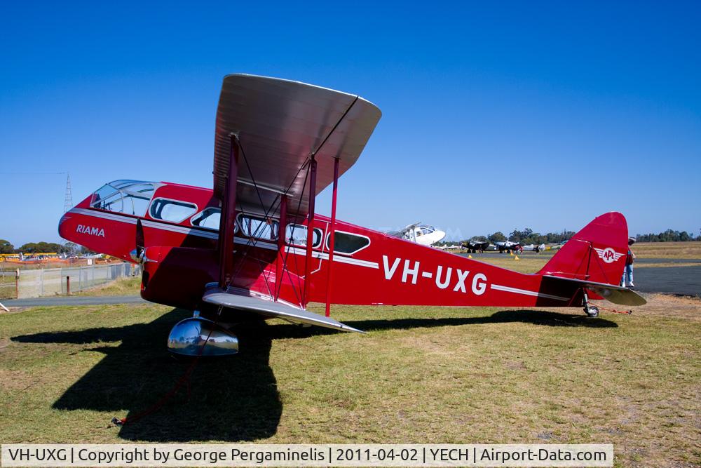
De Havilland DH.84 DragonRegistration
VH-UXG
MSN
6077
Year of Manufacture
1934
Operator
Private AustralianDate
October 1, 2012 at 02:13 PM
Type
CRASHFlight Type
Private
Flight Phase
Flight
Crash Site
Plain, Valley
Crash Location
Borumba Dam Queensland
Region
Oceania • Australia
Crash Cause
Human factor
Narrative Report
On October 1, 2012 at 02:13 PM, Monto - Caboolture experienced a crash involving De Havilland DH.84 Dragon, operated by Private Australian, with the event recorded near Borumba Dam Queensland.
The flight was categorized as private and the reported phase was flight at a plain, valley crash site.
6 people were known to be on board, 6 fatalities were recorded, 0 survivors were identified or estimated. This corresponds to an estimated fatality rate of 100.0%.
Crew on board: 1, crew fatalities: 1, passengers on board: 5, passenger fatalities: 5, other fatalities: 0.
The listed crash cause is human factor. At about 1107 Eastern Standard Time on 01OCT2012, a de Havilland Aircraft Pty Ltd DH-84 Dragon, registered VH-UXG (UXG), took off from Monto on a private flight to Caboolture, Queensland under the visual flight rules (VFR). On board the aircraft were the pilot/owner and five passengers. The weather conditions on departure were reported to include a light south-easterly wind with a high overcast and good visibility. Sometime after about 1230, the aircraft was seen near Tansey, about 150 km north-west of Caboolture on the direct track from Monto to Caboolture. The aircraft was reported flying in a south-easterly direction at the time, at an estimated height of 3,000 ft and in fine but overcast conditions. At 1315, the pilot contacted Brisbane Radar air traffic control (ATC) and advised that the aircraft’s position was about 37 NM (69 km) north of Caboolture and requested navigation assistance. At 1318, the pilot advised ATC that the aircraft was in ‘full cloud’. For most of the remainder of the flight, the pilot and ATC exchanged communications, at times relayed through a commercial flight and a rescue flight in the area due to the limited ATC radio coverage in the area at low altitude. At about 1320, a friend of one of the aircraft’s passengers received a telephone call from the passenger to say that she was in an aircraft and that they were ‘lost in a cloud’ and kept losing altitude. Witnesses in the Borumba Dam, Imbil and Kandanga areas 70 to 80 km north-north-west of Caboolture later reported that they heard and briefly saw the aircraft flying in and out of low cloud between about 1315 and 1415. At 1348, the pilot advised ATC that the aircraft had about an hour’s endurance remaining. The pilot’s last recorded transmission was at 1404. A search for the aircraft was coordinated by Australian Search and Rescue (AusSAR). The aircraft wreckage was located on 3 October 2012, about 87 km north-west of Caboolture on the northern side of a steep, densely wooded ridge about 500 m above mean sea level. The Australian Transport Safety Bureau (ATSB) later determined that the aircraft probably impacted terrain at about 1421 on 01OCT2012. Preliminary analysis indicated that the aircraft collided with trees and terrain at a moderate to high speed, with a left angle of bank. The aircraft’s direction of travel at impact was toward the south-south-west.
Aircraft reference details include registration VH-UXG, MSN 6077, year of manufacture 1934.
Fatalities
Total
6
Crew
1
Passengers
5
Other
0
Crash Summary
At about 1107 Eastern Standard Time on 01OCT2012, a de Havilland Aircraft Pty Ltd DH-84 Dragon, registered VH-UXG (UXG), took off from Monto on a private flight to Caboolture, Queensland under the visual flight rules (VFR). On board the aircraft were the pilot/owner and five passengers. The weather conditions on departure were reported to include a light south-easterly wind with a high overcast and good visibility. Sometime after about 1230, the aircraft was seen near Tansey, about 150 km north-west of Caboolture on the direct track from Monto to Caboolture. The aircraft was reported flying in a south-easterly direction at the time, at an estimated height of 3,000 ft and in fine but overcast conditions. At 1315, the pilot contacted Brisbane Radar air traffic control (ATC) and advised that the aircraft’s position was about 37 NM (69 km) north of Caboolture and requested navigation assistance. At 1318, the pilot advised ATC that the aircraft was in ‘full cloud’. For most of the remainder of the flight, the pilot and ATC exchanged communications, at times relayed through a commercial flight and a rescue flight in the area due to the limited ATC radio coverage in the area at low altitude. At about 1320, a friend of one of the aircraft’s passengers received a telephone call from the passenger to say that she was in an aircraft and that they were ‘lost in a cloud’ and kept losing altitude. Witnesses in the Borumba Dam, Imbil and Kandanga areas 70 to 80 km north-north-west of Caboolture later reported that they heard and briefly saw the aircraft flying in and out of low cloud between about 1315 and 1415. At 1348, the pilot advised ATC that the aircraft had about an hour’s endurance remaining. The pilot’s last recorded transmission was at 1404. A search for the aircraft was coordinated by Australian Search and Rescue (AusSAR). The aircraft wreckage was located on 3 October 2012, about 87 km north-west of Caboolture on the northern side of a steep, densely wooded ridge about 500 m above mean sea level. The Australian Transport Safety Bureau (ATSB) later determined that the aircraft probably impacted terrain at about 1421 on 01OCT2012. Preliminary analysis indicated that the aircraft collided with trees and terrain at a moderate to high speed, with a left angle of bank. The aircraft’s direction of travel at impact was toward the south-south-west.
Cause: Human factor
Occupants & Outcome
Crew On Board
1
Passengers On Board
5
Estimated Survivors
0
Fatality Rate
100.0%
Known people on board: 6
Operational Details
Schedule / Flight
Monto - Caboolture
Operator
Private AustralianFlight Type
Private
Flight Phase
Flight
Crash Site
Plain, Valley
Region / Country
Oceania • Australia
Aircraft Details
Similar Plane Crashes
Royal Australian Air Force - RAAF
Avro 504
The crew was performing a training flight out from Point Cook. Shortly after takeoff, while climbing to an altitude of 500 feet, the aircraft dove into the ground and crashed, bursting into flames. One pilot was killed instantly while the second one died few hours later. This was the first accident involving an aircraft of the Royal Australian Air Force which was officially founded a week ago on March 31, 1921. Crew: Lt James Fryer-Smith, pilot Cpl Bertie W. Whicker, mechanic.
Western Australia Airways
Bristol Tourer
The crew was performing the inaugural flight from Geraldton to Derby which was considered as the first commercial flight within Australia. On approach to Kalbarri, the aircraft crashed for unknown reasons near the Murchinson River, killing both occupants. Crew: Ted Broad, Bob Fawcett.
O. Ramsay
Avro 504
During the takeoff roll, the pilot swerved the airplane to avoid two boys running across the runway. He lost control of the airplane that crashed near the beach. The aircraft was destroyed and all three occupants were injured.
Qantas Airways - Queensland and Northern Territory Aerial Services
Armstrong Whitworth F.K.8
Crashed on takeoff for unknown reasons. While the aircraft was damaged beyond repair, there were no casualties.
Qantas Airways - Queensland and Northern Territory Aerial Services
Armstrong Whitworth F.K.8
En route from Charleville to Longreach, the pilot encountered technical problems and elected to make an emergency landing in Blackall. While the pilot was uninjured, the aircraft was damaged beyond repair.
Royal Australian Air Force - RAAF
Avro 504
The pilot was performing a night training flight at Point Cook Airport. On final approach, he lost control of the aircraft that crashed near the airport. The pilot was injured and the aircraft was damaged beyond repair.