Mesa - Safford
Flight / Schedule
Mesa - Safford
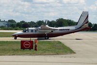
Aircraft
Rockwell Grand Commander 690Registration
N690SM
MSN
690-11337
Year of Manufacture
1976
Operator
Ponderosa AviationDate
November 23, 2011 at 06:31 PM
Type
CRASHFlight Type
Private
Flight Phase
Takeoff (climb)
Crash Site
Mountains
Crash Location
Mesa-Falcon Field Arizona
Region
North America • United States of America
Crash Cause
Human factor
Narrative Report
On November 23, 2011 at 06:31 PM, Mesa - Safford experienced a crash involving Rockwell Grand Commander 690, operated by Ponderosa Aviation, with the event recorded near Mesa-Falcon Field Arizona.
The flight was categorized as private and the reported phase was takeoff (climb) at a mountains crash site.
6 people were known to be on board, 6 fatalities were recorded, 0 survivors were identified or estimated. This corresponds to an estimated fatality rate of 100.0%.
Crew on board: 1, crew fatalities: 1, passengers on board: 5, passenger fatalities: 5, other fatalities: 0.
The listed crash cause is human factor. The aircraft was destroyed when it impacted terrain in the Superstition Mountains near Apache Junction, Arizona. The commercial pilot and the five passengers were fatally injured. The airplane was registered to Ponderosa Aviation, Inc. (PAI) and operated by PAI under the provisions of 14 Code of Federal Regulations (CFR) Part 91 as a personal flight. Night visual meteorological conditions (VMC) prevailed, and no flight plan was filed. The airplane had departed Falcon Field (FFZ), Mesa, Arizona, about 1825 and was destined for Safford Regional Airport (SAD), Safford, Arizona. PAI’s director of maintenance (DOM) and the director of operations (DO), who were co owners of PAI along with the president, conducted a personal flight from SAD to FFZ. The DO flew the leg from SAD to FFZ under visual flight rules (VFR) in night VMC. After arriving at FFZ and in preparation for the flight back to SAD, the DOM moved to the left front seat to act as the pilot flying. The airplane departed FFZ about 12 minutes after it arrived. According to a witness, engine start and taxi-out appeared normal. Review of the recorded communications between the pilot and the FFZ tower air traffic controllers revealed that when the pilot requested taxi clearance, he advised the ground controller that he was planning an "eastbound departure." The flight was cleared for takeoff on runway 4R, and the pilot was instructed to maintain runway heading until advised, due to an inbound aircraft. About 90 seconds later, when the airplane was about 1.1 miles from the departure end of the runway, the tower local controller issued a "right turn approved" advisory to the flight, which the pilot acknowledged. Radar data revealed that the airplane flew the runway heading for about 1.5 miles then began a right turn toward SAD and climbed through an altitude of about 2,600 feet mean sea level (msl). About 1828, after it momentarily climbed to an altitude of 4,700 feet, the airplane descended to an altitude of 4,500 feet, where it remained and tracked in an essentially straight line until it impacted the mountain. The last radar return was received at 1830:56 and was approximately coincident with the impact location. The impact location was near the top of a steep mountain that projected to over 5,000 feet msl. Witnesses reported seeing a fireball, and law enforcement helicopters were dispatched.
Aircraft reference details include registration N690SM, MSN 690-11337, year of manufacture 1976.
Fatalities
Total
6
Crew
1
Passengers
5
Other
0
Crash Summary
The aircraft was destroyed when it impacted terrain in the Superstition Mountains near Apache Junction, Arizona. The commercial pilot and the five passengers were fatally injured. The airplane was registered to Ponderosa Aviation, Inc. (PAI) and operated by PAI under the provisions of 14 Code of Federal Regulations (CFR) Part 91 as a personal flight. Night visual meteorological conditions (VMC) prevailed, and no flight plan was filed. The airplane had departed Falcon Field (FFZ), Mesa, Arizona, about 1825 and was destined for Safford Regional Airport (SAD), Safford, Arizona. PAI’s director of maintenance (DOM) and the director of operations (DO), who were co owners of PAI along with the president, conducted a personal flight from SAD to FFZ. The DO flew the leg from SAD to FFZ under visual flight rules (VFR) in night VMC. After arriving at FFZ and in preparation for the flight back to SAD, the DOM moved to the left front seat to act as the pilot flying. The airplane departed FFZ about 12 minutes after it arrived. According to a witness, engine start and taxi-out appeared normal. Review of the recorded communications between the pilot and the FFZ tower air traffic controllers revealed that when the pilot requested taxi clearance, he advised the ground controller that he was planning an "eastbound departure." The flight was cleared for takeoff on runway 4R, and the pilot was instructed to maintain runway heading until advised, due to an inbound aircraft. About 90 seconds later, when the airplane was about 1.1 miles from the departure end of the runway, the tower local controller issued a "right turn approved" advisory to the flight, which the pilot acknowledged. Radar data revealed that the airplane flew the runway heading for about 1.5 miles then began a right turn toward SAD and climbed through an altitude of about 2,600 feet mean sea level (msl). About 1828, after it momentarily climbed to an altitude of 4,700 feet, the airplane descended to an altitude of 4,500 feet, where it remained and tracked in an essentially straight line until it impacted the mountain. The last radar return was received at 1830:56 and was approximately coincident with the impact location. The impact location was near the top of a steep mountain that projected to over 5,000 feet msl. Witnesses reported seeing a fireball, and law enforcement helicopters were dispatched.
Cause: Human factor
Occupants & Outcome
Crew On Board
1
Passengers On Board
5
Estimated Survivors
0
Fatality Rate
100.0%
Known people on board: 6
Operational Details
Schedule / Flight
Mesa - Safford
Operator
Ponderosa AviationFlight Type
Private
Flight Phase
Takeoff (climb)
Crash Site
Mountains
Region / Country
North America • United States of America
Aircraft Details
Similar Plane Crashes
United States Signal Corps - USSC
De Havilland DH.4
The single engine airplane departed Dayton-McCook Field for a local test flight. Shortly after takeoff, the aircraft stalled and crashed, killing both occupants. Crew: Maj Oscar Brindley, Lt Col Henry Damm.
United States Signal Corps - USSC
De Havilland DH.4
Lt. Frank Stuart Patterson, son and nephew of the co-founders of National Cash Register, is killed in the crash of his DH.4M, AS-32098, at Wilbur Wright Field during a flight test of a new mechanism for synchronizing machine gun and propeller, when a tie rod breaks during a dive from 15,000 feet (4,600 m), causing the wings to separate from the aircraft. Wishing to recognize the contributions of the Patterson family (owners of NCR) the area of Wright Field east of Huffman Dam (including Wilbur Wright Field, Fairfield Air Depot, and the Huffman Prairie) is renamed Patterson Field on 6 July 1931, in honor of Lt. Patterson.
United States Signal Corps - USSC
De Havilland DH.4
The aircraft crashed in unknown circumstances.
United States Signal Corps - USSC
De Havilland DH.4
The crew was completing a training mission. At an altitude of about 4,000 feet, the aircraft entered a spin and crashed in an open field near Everman-Barron Field Airport. A crew was killed and the second occupants was injured. The aircraft was destroyed.
U.S. Air Mail Service
De Havilland DH.4
Crashed following an engine failure. Pilot fate unknown.
United States Signal Corps - USSC
De Havilland DH.4
The accident occurred in unknown circumstances.