Palm Springs - Chino
Flight / Schedule
Palm Springs - Chino
Aircraft
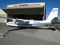
Rockwell Grand Commander 680Registration
N316KW
MSN
680-1753-146
Year of Manufacture
1968
Operator
Christopher J. PetrikasDate
December 20, 2010 at 10:00 AM
Type
CRASHFlight Type
Private
Flight Phase
Flight
Crash Site
Mountains
Crash Location
Perris California
Region
North America • United States of America
Coordinates
33.7819°, -117.2298°
Crash Cause
Human factor
Narrative Report
On December 20, 2010 at 10:00 AM, Palm Springs - Chino experienced a crash involving Rockwell Grand Commander 680, operated by Christopher J. Petrikas, with the event recorded near Perris California.
The flight was categorized as private and the reported phase was flight at a mountains crash site.
1 people were known to be on board, 1 fatalities were recorded, 0 survivors were identified or estimated. This corresponds to an estimated fatality rate of 100.0%.
Crew on board: 1, crew fatalities: 1, passengers on board: 0, passenger fatalities: 0, other fatalities: 0.
The listed crash cause is human factor. The pilot departed the airport mid-morning to fly to his home airport, 63 miles to the northwest. Weather conditions at the departureb airport were visual flight rules (VFR), the weather at the destination airport was not reported, and the weather conditions en-route were marginal VFR. The global positioning system (GPS) track for the flight indicated that the airplane departed from the airport and headed west along a highway corridor flying approximately 1,000 feet above ground level (agl) through a mountain pass. For the majority of the flight, the airplane maintained altitudes between 900 feet and 1,200 feet agl. Twenty-nine minutes after takeoff, the airplane’s GPS track turned southwest away from an area of concentrated precipitation and directly towards an isolated mountain peak that rose approximately 1,000 feet above the surrounding terrain. The pilot contacted the local air traffic control facility, reported his position and requested traffic advisories through the local airspace to his destination airport. About 6 minutes later, the pilot stated that he was having difficulty maintaining VFR and asked for an instrument flight rules (IFR)clearance. At the same time, the GPS track showed that the airplane came within 50 feet of the mountainous terrain. No further transmissions from the pilot were received. The final GPS position was recorded 1 minute later, at 500 feet agl and approximately half a mile from the crash site. The terrain rapidly ascended in this area and intersected the airplane's flight path over the remaining 1/2 mile. An airport located about 4 miles from the accident site and in an area of flat terrain 1,000 feet below the isolated mountain top, recorded weather at the time of the accident as few clouds at 900 feet agl, overcast clouds at 1,500 feet agl, and a variable ceiling between 1,200 and 1,800 feet agl, in drizzle. Weather radar images at the time of the accident depicted precipitation at the elevation and location of the accident site, indicating probable mountain obscuration.
Aircraft reference details include registration N316KW, MSN 680-1753-146, year of manufacture 1968.
Geospatial coordinates for this crash are approximately 33.7819°, -117.2298°.
Fatalities
Total
1
Crew
1
Passengers
0
Other
0
Crash Summary
The pilot departed the airport mid-morning to fly to his home airport, 63 miles to the northwest. Weather conditions at the departureb airport were visual flight rules (VFR), the weather at the destination airport was not reported, and the weather conditions en-route were marginal VFR. The global positioning system (GPS) track for the flight indicated that the airplane departed from the airport and headed west along a highway corridor flying approximately 1,000 feet above ground level (agl) through a mountain pass. For the majority of the flight, the airplane maintained altitudes between 900 feet and 1,200 feet agl. Twenty-nine minutes after takeoff, the airplane’s GPS track turned southwest away from an area of concentrated precipitation and directly towards an isolated mountain peak that rose approximately 1,000 feet above the surrounding terrain. The pilot contacted the local air traffic control facility, reported his position and requested traffic advisories through the local airspace to his destination airport. About 6 minutes later, the pilot stated that he was having difficulty maintaining VFR and asked for an instrument flight rules (IFR)clearance. At the same time, the GPS track showed that the airplane came within 50 feet of the mountainous terrain. No further transmissions from the pilot were received. The final GPS position was recorded 1 minute later, at 500 feet agl and approximately half a mile from the crash site. The terrain rapidly ascended in this area and intersected the airplane's flight path over the remaining 1/2 mile. An airport located about 4 miles from the accident site and in an area of flat terrain 1,000 feet below the isolated mountain top, recorded weather at the time of the accident as few clouds at 900 feet agl, overcast clouds at 1,500 feet agl, and a variable ceiling between 1,200 and 1,800 feet agl, in drizzle. Weather radar images at the time of the accident depicted precipitation at the elevation and location of the accident site, indicating probable mountain obscuration.
Cause: Human factor
Occupants & Outcome
Crew On Board
1
Passengers On Board
0
Estimated Survivors
0
Fatality Rate
100.0%
Known people on board: 1
Operational Details
Schedule / Flight
Palm Springs - Chino
Operator
Christopher J. PetrikasFlight Type
Private
Flight Phase
Flight
Crash Site
Mountains
Region / Country
North America • United States of America
Aircraft Details
Similar Plane Crashes
United States Signal Corps - USSC
De Havilland DH.4
The single engine airplane departed Dayton-McCook Field for a local test flight. Shortly after takeoff, the aircraft stalled and crashed, killing both occupants. Crew: Maj Oscar Brindley, Lt Col Henry Damm.
United States Signal Corps - USSC
De Havilland DH.4
Lt. Frank Stuart Patterson, son and nephew of the co-founders of National Cash Register, is killed in the crash of his DH.4M, AS-32098, at Wilbur Wright Field during a flight test of a new mechanism for synchronizing machine gun and propeller, when a tie rod breaks during a dive from 15,000 feet (4,600 m), causing the wings to separate from the aircraft. Wishing to recognize the contributions of the Patterson family (owners of NCR) the area of Wright Field east of Huffman Dam (including Wilbur Wright Field, Fairfield Air Depot, and the Huffman Prairie) is renamed Patterson Field on 6 July 1931, in honor of Lt. Patterson.
United States Signal Corps - USSC
De Havilland DH.4
The aircraft crashed in unknown circumstances.
United States Signal Corps - USSC
De Havilland DH.4
The crew was completing a training mission. At an altitude of about 4,000 feet, the aircraft entered a spin and crashed in an open field near Everman-Barron Field Airport. A crew was killed and the second occupants was injured. The aircraft was destroyed.
U.S. Air Mail Service
De Havilland DH.4
Crashed following an engine failure. Pilot fate unknown.
United States Signal Corps - USSC
De Havilland DH.4
The accident occurred in unknown circumstances.