Frankfurt – Reichelsheim
Flight / Schedule
Frankfurt – Reichelsheim
Aircraft
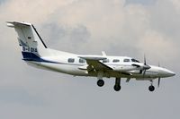
Piper PA-42 CheyenneRegistration
D-IDIA
MSN
42-5501055
Year of Manufacture
1990
Operator
Heli-FlightDate
January 19, 2009 at 12:40 PM
Type
CRASHFlight Type
Positioning
Flight Phase
Takeoff (climb)
Crash Site
Plain, Valley
Crash Location
Königstein im Taunus Hesse
Region
Europe • Germany
Coordinates
50.1951°, 8.4628°
Crash Cause
Human factor
Narrative Report
On January 19, 2009 at 12:40 PM, Frankfurt – Reichelsheim experienced a crash involving Piper PA-42 Cheyenne, operated by Heli-Flight, with the event recorded near Königstein im Taunus Hesse.
The flight was categorized as positioning and the reported phase was takeoff (climb) at a plain, valley crash site.
1 people were known to be on board, 1 fatalities were recorded, 0 survivors were identified or estimated. This corresponds to an estimated fatality rate of 100.0%.
Crew on board: 1, crew fatalities: 1, passengers on board: 0, passenger fatalities: 0, other fatalities: 0.
The listed crash cause is human factor. The pilot, sole on board, was completing a positioning flight from Frankfurt-Main Airport to Reichelsheim where the airplane was based. At 1235LT, the twin engine aircraft departed Frankfurt-Main Airport runway 25L and the pilot was instructed to make a left turn and to climb and maintain 1,500 feet. The aircraft climbed to 1,800 feet then descended to 1,400 feet. In rain falls, the aircraft struck trees and crashed in a wooded area located in Königstein im Taunus, about 15 km north of Frankfurt Airport. The aircraft was totally destroyed and the pilot was killed.
Aircraft reference details include registration D-IDIA, MSN 42-5501055, year of manufacture 1990.
Geospatial coordinates for this crash are approximately 50.1951°, 8.4628°.
Fatalities
Total
1
Crew
1
Passengers
0
Other
0
Crash Summary
The pilot, sole on board, was completing a positioning flight from Frankfurt-Main Airport to Reichelsheim where the airplane was based. At 1235LT, the twin engine aircraft departed Frankfurt-Main Airport runway 25L and the pilot was instructed to make a left turn and to climb and maintain 1,500 feet. The aircraft climbed to 1,800 feet then descended to 1,400 feet. In rain falls, the aircraft struck trees and crashed in a wooded area located in Königstein im Taunus, about 15 km north of Frankfurt Airport. The aircraft was totally destroyed and the pilot was killed.
Cause: Human factor
Occupants & Outcome
Crew On Board
1
Passengers On Board
0
Estimated Survivors
0
Fatality Rate
100.0%
Known people on board: 1
Operational Details
Schedule / Flight
Frankfurt – Reichelsheim
Operator
Heli-FlightFlight Type
Positioning
Flight Phase
Takeoff (climb)
Crash Site
Plain, Valley
Region / Country
Europe • Germany
Aircraft Details
Similar Plane Crashes
United States Army Air Service - USAAS
De Havilland DH.4
Crashed in unknown circumstances.
Deutsche Luft-Reederei
LVG C.VI
Crashed shortly after takeoff from Dortmund Airport. Both occupants were injured and the aircraft was destroyed.
United States Army Air Service - USAAS
De Havilland DH.4
Crashed following an engine failure in flight. Crew fate unknown.
Rumpler Luftverkehr
Junkers F.13
The aircraft crashed shortly after takeoff from Munich-Oberschleissheim Airport. The pilot Höpken escaped uninjured.
Compagnie Internationale de Navigation Aérienne - CIDNA
Farman F.121 Jabiru
Crashed in unknown circumstances. Occupant fate unknown.
Deutscher Aero Lloyd
Junkers F.13
The single engine airplane departed Munich-Oberschleissheim Airport on a regular service to Leipzig with three passengers and one pilot on board. While flying over Bavaria, the pilot encountered poor weather conditions with thunderstorm activity. He attempted an emergency landing when the aircraft crashed in an open field located in Kulmbach. All four occupants evacuated safely and the aircraft was damaged beyond repair.