Millington - Millington
Flight / Schedule
Millington - Millington
Aircraft
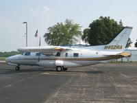
Mitsubishi MU-2 MarquiseRegistration
N452MA
MSN
1533
Year of Manufacture
1981
Operator
Briggs Tobacco %26 Specialty CompanyDate
December 9, 2008 at 10:58 AM
Type
CRASHFlight Type
Positioning
Flight Phase
Landing (descent or approach)
Crash Site
Airport (less than 10 km from airport)
Crash Location
Millington-Memphis Tennessee
Region
North America • United States of America
Coordinates
35.2172°, -89.9273°
Crash Cause
Human factor
Narrative Report
On December 9, 2008 at 10:58 AM, Millington - Millington experienced a crash involving Mitsubishi MU-2 Marquise, operated by Briggs Tobacco %26 Specialty Company, with the event recorded near Millington-Memphis Tennessee.
The flight was categorized as positioning and the reported phase was landing (descent or approach) at a airport (less than 10 km from airport) crash site.
1 people were known to be on board, 0 fatalities were recorded, 1 survivors were identified or estimated. This corresponds to an estimated fatality rate of 0.0%.
Crew on board: 1, crew fatalities: 0, passengers on board: 0, passenger fatalities: 0, other fatalities: 0.
The listed crash cause is human factor. According to the pilot, after he took off for a nearby airport he raised the landing gear but did not raise the 20-degree flaps per the “after takeoff” checklist. Shortly thereafter, when the airplane was at an altitude of about 2,400 feet, and in "heavy rain," the pilot noticed that the right engine was losing power. He subsequently feathered the propeller as engine power reduced to 40 percent, but still did not raise the flaps. Weather, recorded shortly before the accident, included scattered clouds at 500 feet, and a broken cloud layer at 1,200 feet, and the pilot advised air traffic control (ATC) that he would fly an ILS (instrument landing system) approach if he could maintain altitude. After maneuvering, and advising ATC that he could not maintain altitude, the pilot descended the airplane to a right base leg where, about 1/4 nautical mile from the runway, it was approximately 300 feet above the terrain. The pilot completed the landing, with the airplane touching down about 6,200 feet down the 8,000-foot runway, heading about 20 degrees to the left. The airplane veered off the left side of the runway and subsequently went through an airport fence. The left engine was running at “high speed” when fire fighters responded to the scene. The right engine propeller was observed in the feathered position at the scene, and after subsequent examinations, the right engine was successfully run in a test cell with no noticeable loss of power. There was no determination as to why the right engine lost power in flight, although rain ingestion is a possibility. Airplane performance calculations indicated that with the landing gear up, a proper single-engine power setting and airspeed, and flaps raised, the airplane should have been able to climb about 650 feet per minute. Even with flaps at 20 degrees, it should have been able to climb at 350 feet per minute. In either case, unless the airplane was not properly configured, there was no reason why it should not have been able to maintain the altitudes needed to position it for a stabilized approach.
Aircraft reference details include registration N452MA, MSN 1533, year of manufacture 1981.
Geospatial coordinates for this crash are approximately 35.2172°, -89.9273°.
Fatalities
Total
0
Crew
0
Passengers
0
Other
0
Crash Summary
According to the pilot, after he took off for a nearby airport he raised the landing gear but did not raise the 20-degree flaps per the “after takeoff” checklist. Shortly thereafter, when the airplane was at an altitude of about 2,400 feet, and in "heavy rain," the pilot noticed that the right engine was losing power. He subsequently feathered the propeller as engine power reduced to 40 percent, but still did not raise the flaps. Weather, recorded shortly before the accident, included scattered clouds at 500 feet, and a broken cloud layer at 1,200 feet, and the pilot advised air traffic control (ATC) that he would fly an ILS (instrument landing system) approach if he could maintain altitude. After maneuvering, and advising ATC that he could not maintain altitude, the pilot descended the airplane to a right base leg where, about 1/4 nautical mile from the runway, it was approximately 300 feet above the terrain. The pilot completed the landing, with the airplane touching down about 6,200 feet down the 8,000-foot runway, heading about 20 degrees to the left. The airplane veered off the left side of the runway and subsequently went through an airport fence. The left engine was running at “high speed” when fire fighters responded to the scene. The right engine propeller was observed in the feathered position at the scene, and after subsequent examinations, the right engine was successfully run in a test cell with no noticeable loss of power. There was no determination as to why the right engine lost power in flight, although rain ingestion is a possibility. Airplane performance calculations indicated that with the landing gear up, a proper single-engine power setting and airspeed, and flaps raised, the airplane should have been able to climb about 650 feet per minute. Even with flaps at 20 degrees, it should have been able to climb at 350 feet per minute. In either case, unless the airplane was not properly configured, there was no reason why it should not have been able to maintain the altitudes needed to position it for a stabilized approach.
Cause: Human factor
Occupants & Outcome
Crew On Board
1
Passengers On Board
0
Estimated Survivors
1
Fatality Rate
0.0%
Known people on board: 1
Operational Details
Schedule / Flight
Millington - Millington
Operator
Briggs Tobacco %26 Specialty CompanyFlight Type
Positioning
Flight Phase
Landing (descent or approach)
Crash Site
Airport (less than 10 km from airport)
Region / Country
North America • United States of America
Aircraft Details
Similar Plane Crashes
United States Signal Corps - USSC
De Havilland DH.4
The single engine airplane departed Dayton-McCook Field for a local test flight. Shortly after takeoff, the aircraft stalled and crashed, killing both occupants. Crew: Maj Oscar Brindley, Lt Col Henry Damm.
United States Signal Corps - USSC
De Havilland DH.4
Lt. Frank Stuart Patterson, son and nephew of the co-founders of National Cash Register, is killed in the crash of his DH.4M, AS-32098, at Wilbur Wright Field during a flight test of a new mechanism for synchronizing machine gun and propeller, when a tie rod breaks during a dive from 15,000 feet (4,600 m), causing the wings to separate from the aircraft. Wishing to recognize the contributions of the Patterson family (owners of NCR) the area of Wright Field east of Huffman Dam (including Wilbur Wright Field, Fairfield Air Depot, and the Huffman Prairie) is renamed Patterson Field on 6 July 1931, in honor of Lt. Patterson.
United States Signal Corps - USSC
De Havilland DH.4
The aircraft crashed in unknown circumstances.
United States Signal Corps - USSC
De Havilland DH.4
The crew was completing a training mission. At an altitude of about 4,000 feet, the aircraft entered a spin and crashed in an open field near Everman-Barron Field Airport. A crew was killed and the second occupants was injured. The aircraft was destroyed.
U.S. Air Mail Service
De Havilland DH.4
Crashed following an engine failure. Pilot fate unknown.
United States Signal Corps - USSC
De Havilland DH.4
The accident occurred in unknown circumstances.