El Paso - Presidio
Flight / Schedule
El Paso - Presidio
Aircraft
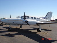
Cessna 421B Golden Eagle IIRegistration
N7560Q
MSN
421B-0346
Year of Manufacture
1973
Operator
Volare Air Charter CompanyDate
September 14, 2008 at 01:18 PM
Type
CRASHFlight Type
Survey / Patrol / Reconnaissance
Flight Phase
Flight
Crash Site
Mountains
Crash Location
San Antonio del Bravo Chihuahua
Region
Central America • Mexico
Coordinates
30.1372°, -104.7016°
Crash Cause
Human factor
Narrative Report
On September 14, 2008 at 01:18 PM, El Paso - Presidio experienced a crash involving Cessna 421B Golden Eagle II, operated by Volare Air Charter Company, with the event recorded near San Antonio del Bravo Chihuahua.
The flight was categorized as survey / patrol / reconnaissance and the reported phase was flight at a mountains crash site.
4 people were known to be on board, 4 fatalities were recorded, 0 survivors were identified or estimated. This corresponds to an estimated fatality rate of 100.0%.
Crew on board: 1, crew fatalities: 1, passengers on board: 3, passenger fatalities: 3, other fatalities: 0.
The listed crash cause is human factor. On September 15, 2008 Cessna 421B, N7560Q, was substantially damaged after it collided with mountainous terrain approximately 28 miles northwest of Ojinaga, Mexico, near the border town of Presidio, Texas. The air transport rated pilot and the three passengers were fatally injured. The pilot contacted the Fort Worth Automated Flight Service Station (AFSS), Fort Worth, Texas, at 1016, approximately 15 minutes after he departed El Paso International Airport, El Paso, Texas, and filed a visual flight rules flight plan to Presidio, Texas. The pilot informed an AFSS specialist that he intended to enter Mexican airspace for the purpose of flying over the Luis Leon Dam, but had no intentions of landing in Mexico. The pilot did not request a weather briefing for the flight however, he was informed by the specialist that visual flight rules were not recommended due to mountain obscuration. Onboard the airplane were the pilot, the United States and Mexican Commissioners of the International Boundary and Water Commission (IBWC), and the Executive Director for the Rio Grande Council of Governments. The purpose of the flight was to assess Rio Grande flood conditions at Presidio-Ojinaga and to coordinate joint US-Mexican efforts with local officials to address flood control concerns in the area due to heavy inflows to the Rio Grande from reservoirs inside Mexico as a result of recent storms. The airplane wreckage was located on September 17, 2008, by the Marfa Sector of the US Customs and Border Protection Air and Marine Division, on the west side of the Sierra Grande Mountains, at an approximate elevation of 6,500 feet mean sea level (msl). The airplane came to rest approximately 100-150 feet below the top of a ridgeline on a heading of 055 degrees along victor-airway V81.
Aircraft reference details include registration N7560Q, MSN 421B-0346, year of manufacture 1973.
Geospatial coordinates for this crash are approximately 30.1372°, -104.7016°.
Fatalities
Total
4
Crew
1
Passengers
3
Other
0
Crash Summary
On September 15, 2008 Cessna 421B, N7560Q, was substantially damaged after it collided with mountainous terrain approximately 28 miles northwest of Ojinaga, Mexico, near the border town of Presidio, Texas. The air transport rated pilot and the three passengers were fatally injured. The pilot contacted the Fort Worth Automated Flight Service Station (AFSS), Fort Worth, Texas, at 1016, approximately 15 minutes after he departed El Paso International Airport, El Paso, Texas, and filed a visual flight rules flight plan to Presidio, Texas. The pilot informed an AFSS specialist that he intended to enter Mexican airspace for the purpose of flying over the Luis Leon Dam, but had no intentions of landing in Mexico. The pilot did not request a weather briefing for the flight however, he was informed by the specialist that visual flight rules were not recommended due to mountain obscuration. Onboard the airplane were the pilot, the United States and Mexican Commissioners of the International Boundary and Water Commission (IBWC), and the Executive Director for the Rio Grande Council of Governments. The purpose of the flight was to assess Rio Grande flood conditions at Presidio-Ojinaga and to coordinate joint US-Mexican efforts with local officials to address flood control concerns in the area due to heavy inflows to the Rio Grande from reservoirs inside Mexico as a result of recent storms. The airplane wreckage was located on September 17, 2008, by the Marfa Sector of the US Customs and Border Protection Air and Marine Division, on the west side of the Sierra Grande Mountains, at an approximate elevation of 6,500 feet mean sea level (msl). The airplane came to rest approximately 100-150 feet below the top of a ridgeline on a heading of 055 degrees along victor-airway V81.
Cause: Human factor
Occupants & Outcome
Crew On Board
1
Passengers On Board
3
Estimated Survivors
0
Fatality Rate
100.0%
Known people on board: 4
Operational Details
Schedule / Flight
El Paso - Presidio
Operator
Volare Air Charter CompanyFlight Type
Survey / Patrol / Reconnaissance
Flight Phase
Flight
Crash Site
Mountains
Region / Country
Central America • Mexico
Aircraft Details
Similar Plane Crashes
United States Army Air Service - USAAS
De Havilland DH.4
The pilot, sole on board, was performing a training flight at the border between US and Mexico. In flight, the engine failed and the pilot was forced to attempte an emergency landing near Tijuana, Baja California, Mexico. The pilot was uninjured and the aircraft was damaged beyond repair.
Mexicana de Aviación
Ford 4
Shortly after takeoff, while climbing to a height of 100 feet, one of the engine failed. The aircraft stalled and crashed, killing all five occupants, among them pilot Dennis W. Taylor.
Corporación Aeronautica de Transportes
Lockheed 5 Vega
En route from Matamoros to Mexico City and while overflying north of the State of Veracruz, the single engine aircraft hit the Cerro de Carbón located south of Papantla. The airplane was destroyed by impact forces and all four occupants were killed. The aircraft was supposed to be registered XA-BHH but this registration was not taken up at the time of the accident.
Corporación Aeronautica de Transportes
Lockheed 5 Vega
Crashed in unknown circumstances near Monterrey and was destroyed by fire. Occupant fate unknown.
Government of the State of Yucatán
Sikorsky S-38
The seaplane named 'Mayab' crashed in unknown circumstances in Mérida, killing all five occupants.
Corporación Aeronautica de Transportes
Ryan B-1 Brougham
The crew was completing a local training flight at Torreón Airport when the accident occurred in unknown circumstances. The aircraft was destroyed and all three occupants were killed.