Kenai - Anchorage
Flight / Schedule
Kenai - Anchorage
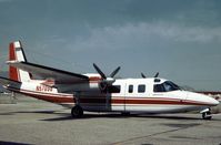
Aircraft
Rockwell Grand Commander 690Registration
N57096
MSN
690-11120
Year of Manufacture
1973
Operator
Commander NorthwestDate
July 28, 2006 at 08:37 PM
Type
CRASHFlight Type
Training
Flight Phase
Landing (descent or approach)
Crash Site
Lake, Sea, Ocean, River
Crash Location
Anchorage Alaska
Region
North America • United States of America
Coordinates
61.2163°, -149.8949°
Narrative Report
On July 28, 2006 at 08:37 PM, Kenai - Anchorage experienced a crash involving Rockwell Grand Commander 690, operated by Commander Northwest, with the event recorded near Anchorage Alaska.
The flight was categorized as training and the reported phase was landing (descent or approach) at a lake, sea, ocean, river crash site.
3 people were known to be on board, 3 fatalities were recorded, 0 survivors were identified or estimated. This corresponds to an estimated fatality rate of 100.0%.
Crew on board: 2, crew fatalities: 2, passengers on board: 1, passenger fatalities: 1, other fatalities: 0.
The crew of the missing airplane was conducting a local area familiarization flight under Title 14, CFR Part 91. At the time of the flight, visual meteorological conditions prevailed, with occasional moderate turbulence forecast for the area. The airplane was routinely contracted for animal and bird counts, and the flight was to include low level flight simulating such a mission. The three occupants of the airplane were the pilot, company check pilot, and another company pilot riding along as a passenger. Both the pilot and the check pilot held airline transport certificates, and were experienced in the make and model of the accident airplane. The airplane was equipped with a satellite position reporting device that updated position, groundspeed, and altitude every 2 minutes. Radar and GPS track information indicated the accident airplane was flying low and slow along a peninsula coast over a saltwater inlet, and turned toward the center of the inlet. The track stopped about 3 miles offshore. The data indicated that while flying along the inlet, the airplane descended to 112 feet above ground level (water), and climbed as high as 495 feet, which was the airplane's altitude at the last data point. The airplane's groundspeed varied between 97 and 111 knots. The area of the presumed crash site experiences extreme tides and strong currents, with reduced visibility due to a high glacial silt content. An extensive search was conducted, but the airplane and its occupants have not been located. An examination of the airplane's maintenance logs did not disclose any unresolved maintenance issues.
Aircraft reference details include registration N57096, MSN 690-11120, year of manufacture 1973.
Geospatial coordinates for this crash are approximately 61.2163°, -149.8949°.
Fatalities
Total
3
Crew
2
Passengers
1
Other
0
Crash Summary
The crew of the missing airplane was conducting a local area familiarization flight under Title 14, CFR Part 91. At the time of the flight, visual meteorological conditions prevailed, with occasional moderate turbulence forecast for the area. The airplane was routinely contracted for animal and bird counts, and the flight was to include low level flight simulating such a mission. The three occupants of the airplane were the pilot, company check pilot, and another company pilot riding along as a passenger. Both the pilot and the check pilot held airline transport certificates, and were experienced in the make and model of the accident airplane. The airplane was equipped with a satellite position reporting device that updated position, groundspeed, and altitude every 2 minutes. Radar and GPS track information indicated the accident airplane was flying low and slow along a peninsula coast over a saltwater inlet, and turned toward the center of the inlet. The track stopped about 3 miles offshore. The data indicated that while flying along the inlet, the airplane descended to 112 feet above ground level (water), and climbed as high as 495 feet, which was the airplane's altitude at the last data point. The airplane's groundspeed varied between 97 and 111 knots. The area of the presumed crash site experiences extreme tides and strong currents, with reduced visibility due to a high glacial silt content. An extensive search was conducted, but the airplane and its occupants have not been located. An examination of the airplane's maintenance logs did not disclose any unresolved maintenance issues.
Occupants & Outcome
Crew On Board
2
Passengers On Board
1
Estimated Survivors
0
Fatality Rate
100.0%
Known people on board: 3
Operational Details
Schedule / Flight
Kenai - Anchorage
Operator
Commander NorthwestFlight Type
Training
Flight Phase
Landing (descent or approach)
Crash Site
Lake, Sea, Ocean, River
Region / Country
North America • United States of America
Aircraft Details
Similar Plane Crashes
United States Signal Corps - USSC
De Havilland DH.4
The single engine airplane departed Dayton-McCook Field for a local test flight. Shortly after takeoff, the aircraft stalled and crashed, killing both occupants. Crew: Maj Oscar Brindley, Lt Col Henry Damm.
United States Signal Corps - USSC
De Havilland DH.4
Lt. Frank Stuart Patterson, son and nephew of the co-founders of National Cash Register, is killed in the crash of his DH.4M, AS-32098, at Wilbur Wright Field during a flight test of a new mechanism for synchronizing machine gun and propeller, when a tie rod breaks during a dive from 15,000 feet (4,600 m), causing the wings to separate from the aircraft. Wishing to recognize the contributions of the Patterson family (owners of NCR) the area of Wright Field east of Huffman Dam (including Wilbur Wright Field, Fairfield Air Depot, and the Huffman Prairie) is renamed Patterson Field on 6 July 1931, in honor of Lt. Patterson.
United States Signal Corps - USSC
De Havilland DH.4
The aircraft crashed in unknown circumstances.
United States Signal Corps - USSC
De Havilland DH.4
The crew was completing a training mission. At an altitude of about 4,000 feet, the aircraft entered a spin and crashed in an open field near Everman-Barron Field Airport. A crew was killed and the second occupants was injured. The aircraft was destroyed.
U.S. Air Mail Service
De Havilland DH.4
Crashed following an engine failure. Pilot fate unknown.
United States Signal Corps - USSC
De Havilland DH.4
The accident occurred in unknown circumstances.