Dayton - Harlingen
Flight / Schedule
Dayton - Harlingen
Aircraft
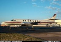
Swearingen SA226 Metro IIRegistration
N629EK
MSN
TC-396
Year of Manufacture
1980
Operator
TriCoastal AirDate
February 8, 2006 at 12:10 PM
Type
CRASHFlight Type
Cargo
Flight Phase
Flight
Crash Site
Plain, Valley
Crash Location
Paris Tennessee
Region
North America • United States of America
Coordinates
36.3019°, -88.3259°
Crash Cause
Technical failure
Narrative Report
On February 8, 2006 at 12:10 PM, Dayton - Harlingen experienced a crash involving Swearingen SA226 Metro II, operated by TriCoastal Air, with the event recorded near Paris Tennessee.
The flight was categorized as cargo and the reported phase was flight at a plain, valley crash site.
1 people were known to be on board, 1 fatalities were recorded, 0 survivors were identified or estimated. This corresponds to an estimated fatality rate of 100.0%.
Crew on board: 1, crew fatalities: 1, passengers on board: 0, passenger fatalities: 0, other fatalities: 0.
The listed crash cause is technical failure. While in cruise flight at 16,000 feet, the pilot requested from ATC and was cleared to make a 360-degree turn to the left. Shortly after this, the pilot requested a 360-degree turn to the right. The pilot then requested radar vectors to the closest airport and was given this. ATC asked the pilot if he had an emergency and the pilot reported he had an asymmetric fuel condition. The pilot then asked for a lower altitude and was cleared by ATC to 4,000 feet. About a minute later the pilot transmitted "Mayday" six times and shortly after this radar and radio contact with the flight was lost. Recorded radar data showed that at 1803:13 the accident airplane was proceeding on a southerly heading at 16,100 feet mean sea level (MSL). At 1803:53 the airplane turned left to a southeasterly heading. At 1804:13 the airplane turned right returning to its original southerly heading. At 1805:14 the accident airplane turned to the right on a southwesterly heading, and maintained that heading until 1809:04 at which time the airplane turned due west and was at an altitude of 15,400 feet. The last radar contact was at 1810:06 at an altitude of 13,800 feet. The airplane wreckage was located due north from this last recorded radar contact. Witnesses observed the airplane descend in a near vertical attitude, collide with the ground, and then explode. Components from all areas of the aircraft structure and flight control surfaces were located at the crash site along with components from both engines and propellers. Impact and post crash fire damage precluded the examination of the airplanes fuel system and components.
Aircraft reference details include registration N629EK, MSN TC-396, year of manufacture 1980.
Geospatial coordinates for this crash are approximately 36.3019°, -88.3259°.
Fatalities
Total
1
Crew
1
Passengers
0
Other
0
Crash Summary
While in cruise flight at 16,000 feet, the pilot requested from ATC and was cleared to make a 360-degree turn to the left. Shortly after this, the pilot requested a 360-degree turn to the right. The pilot then requested radar vectors to the closest airport and was given this. ATC asked the pilot if he had an emergency and the pilot reported he had an asymmetric fuel condition. The pilot then asked for a lower altitude and was cleared by ATC to 4,000 feet. About a minute later the pilot transmitted "Mayday" six times and shortly after this radar and radio contact with the flight was lost. Recorded radar data showed that at 1803:13 the accident airplane was proceeding on a southerly heading at 16,100 feet mean sea level (MSL). At 1803:53 the airplane turned left to a southeasterly heading. At 1804:13 the airplane turned right returning to its original southerly heading. At 1805:14 the accident airplane turned to the right on a southwesterly heading, and maintained that heading until 1809:04 at which time the airplane turned due west and was at an altitude of 15,400 feet. The last radar contact was at 1810:06 at an altitude of 13,800 feet. The airplane wreckage was located due north from this last recorded radar contact. Witnesses observed the airplane descend in a near vertical attitude, collide with the ground, and then explode. Components from all areas of the aircraft structure and flight control surfaces were located at the crash site along with components from both engines and propellers. Impact and post crash fire damage precluded the examination of the airplanes fuel system and components.
Cause: Technical failure
Occupants & Outcome
Crew On Board
1
Passengers On Board
0
Estimated Survivors
0
Fatality Rate
100.0%
Known people on board: 1
Operational Details
Schedule / Flight
Dayton - Harlingen
Operator
TriCoastal AirFlight Type
Cargo
Flight Phase
Flight
Crash Site
Plain, Valley
Region / Country
North America • United States of America
Aircraft Details
Similar Plane Crashes
United States Signal Corps - USSC
De Havilland DH.4
The single engine airplane departed Dayton-McCook Field for a local test flight. Shortly after takeoff, the aircraft stalled and crashed, killing both occupants. Crew: Maj Oscar Brindley, Lt Col Henry Damm.
United States Signal Corps - USSC
De Havilland DH.4
Lt. Frank Stuart Patterson, son and nephew of the co-founders of National Cash Register, is killed in the crash of his DH.4M, AS-32098, at Wilbur Wright Field during a flight test of a new mechanism for synchronizing machine gun and propeller, when a tie rod breaks during a dive from 15,000 feet (4,600 m), causing the wings to separate from the aircraft. Wishing to recognize the contributions of the Patterson family (owners of NCR) the area of Wright Field east of Huffman Dam (including Wilbur Wright Field, Fairfield Air Depot, and the Huffman Prairie) is renamed Patterson Field on 6 July 1931, in honor of Lt. Patterson.
United States Signal Corps - USSC
De Havilland DH.4
The aircraft crashed in unknown circumstances.
United States Signal Corps - USSC
De Havilland DH.4
The crew was completing a training mission. At an altitude of about 4,000 feet, the aircraft entered a spin and crashed in an open field near Everman-Barron Field Airport. A crew was killed and the second occupants was injured. The aircraft was destroyed.
U.S. Air Mail Service
De Havilland DH.4
Crashed following an engine failure. Pilot fate unknown.
United States Signal Corps - USSC
De Havilland DH.4
The accident occurred in unknown circumstances.